You are here: Home > Network List > XE05 - Sierra Nevada EarthScope Project- EarthScope Flex Array Stations List
> Station SNP96 SNP96 > Earthquake Result Viewer
SNP96 SNP96 - Earthquake Result Viewer
| Earthquake location: |
Peru-Brazil Border Region |
| Earthquake latitude/longitude: |
-7.9/-74.4 |
| Earthquake time(UTC): |
2007/07/12 (193) 05:23:49 GMT |
| Earthquake Depth: |
152 km |
| Earthquake Magnitude: |
5.9 MB, 6.1 MW, 6.0 MW |
| Earthquake Catalog/Contributor: |
WHDF/NEIC |
|
| Network: |
XE Sierra Nevada EarthScope Project- EarthScope Flex Array |
| Station: |
SNP96 SNP96 |
| Lat/Lon: |
38.48 N/120.04 W |
| Elevation: |
2243 m |
|
| Distance: |
62.7 deg |
| Az: |
320.825 deg |
| Baz: |
127.138 deg |
| Ray Param: |
0.059600163 |
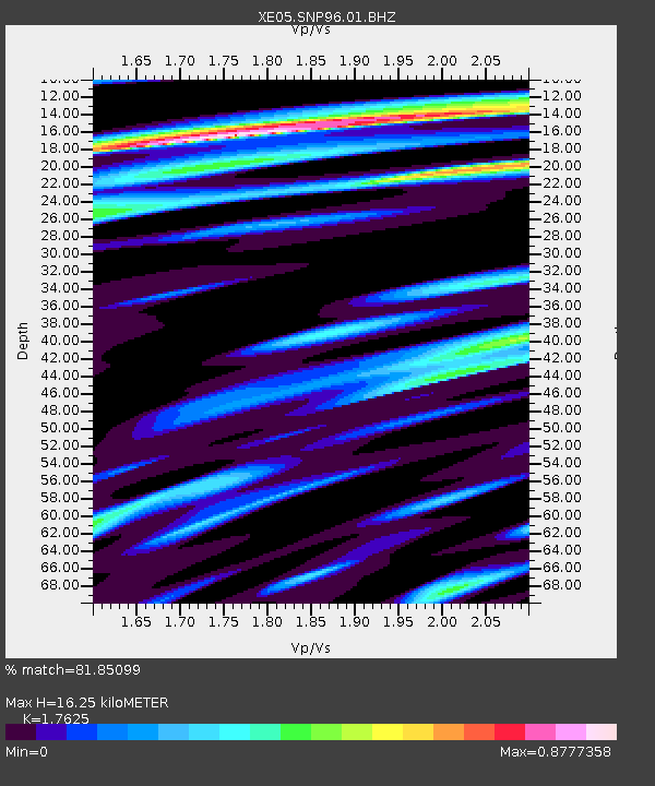
| Estimated Moho Depth: |
16.25 km |
| Estimated Crust Vp/Vs: |
1.76 |
| Assumed Crust Vp: |
6.597 km/s |
| Estimated Crust Vs: |
3.743 km/s |
| Estimated Crust Poisson's Ratio: |
0.26 |
|
| Radial Match: |
81.85099 % |
| Radial Bump: |
400 |
| Transverse Match: |
75.09439 % |
| Transverse Bump: |
400 |
| SOD ConfigId: |
268666 |
| Insert Time: |
2010-03-09 17:35:43.929 +0000 |
| GWidth: |
2.5 |
| Max Bumps: |
400 |
| Tol: |
0.001 |
|

Signal To Noise
| Channel | StoN | STA | LTA |
| XE:SNP96:01:BHZ:20070712T05:33:27.340Z | 9.900517 | 5.2896394E-7 | 5.342791E-8 |
| XE:SNP96:01:BHN:20070712T05:33:27.340Z | 3.3748548 | 1.4361554E-7 | 4.2554582E-8 |
| XE:SNP96:01:BHE:20070712T05:33:27.340Z | 4.7029066 | 1.429433E-7 | 3.039467E-8 |
| Arrivals |
| Ps | 2.0 SECOND |
| PpPs | 6.5 SECOND |
| PsPs/PpSs | 8.5 SECOND |


