You are here: Home > Network List > II - Global Seismograph Network (GSN - IRIS/IDA) Stations List
> Station BFO Black Forest Observatory, Schiltach, Germany > Earthquake Result Viewer
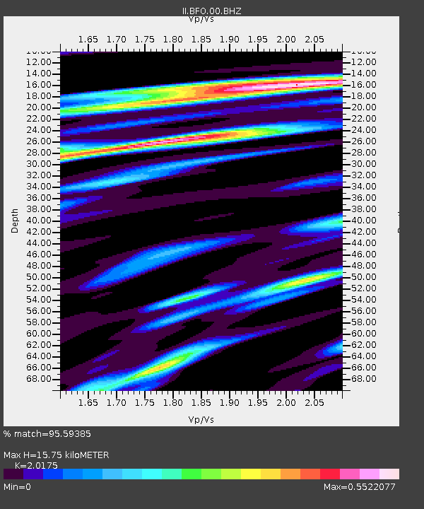
BFO Black Forest Observatory, Schiltach, Germany - Earthquake Result Viewer
| Earthquake location: |
Near East Coast Of Honshu, Japan |
| Earthquake latitude/longitude: |
37.7/141.6 |
| Earthquake time(UTC): |
2022/03/16 (075) 14:36:33 GMT |
| Earthquake Depth: |
63 km |
| Earthquake Magnitude: |
7.3 mww |
| Earthquake Catalog/Contributor: |
NEIC PDE/us |
|
| Network: |
II Global Seismograph Network (GSN - IRIS/IDA) |
| Station: |
BFO Black Forest Observatory, Schiltach, Germany |
| Lat/Lon: |
48.33 N/8.33 E |
| Elevation: |
589 m |
|
| Distance: |
84.8 deg |
| Az: |
330.79 deg |
| Baz: |
35.456 deg |
| Ray Param: |
0.04511758 |
| Estimated Moho Depth: |
15.75 km |
| Estimated Crust Vp/Vs: |
2.02 |
| Assumed Crust Vp: |
6.264 km/s |
| Estimated Crust Vs: |
3.105 km/s |
| Estimated Crust Poisson's Ratio: |
0.34 |
|
| Radial Match: |
95.59385 % |
| Radial Bump: |
307 |
| Transverse Match: |
91.291595 % |
| Transverse Bump: |
400 |
| SOD ConfigId: |
27527651 |
| Insert Time: |
2022-03-30 15:35:31.657 +0000 |
| GWidth: |
2.5 |
| Max Bumps: |
400 |
| Tol: |
0.001 |
|

Signal To Noise
| Channel | StoN | STA | LTA |
| II:BFO:00:BHZ:20220316T14:48:29.61898Z | 8.737169 | 4.104051E-6 | 4.697232E-7 |
| II:BFO:00:BHN:20220316T14:48:29.61898Z | 1.8695437 | 1.1119229E-6 | 5.9475633E-7 |
| II:BFO:00:BHE:20220316T14:48:29.61898Z | 4.053707 | 7.998466E-7 | 1.9731239E-7 |
| Arrivals |
| Ps | 2.6 SECOND |
| PpPs | 7.4 SECOND |
| PsPs/PpSs | 10 SECOND |


