You are here: Home > Network List > IU - Global Seismograph Network (GSN - IRIS/USGS) Stations List
> Station CTAO Charters Towers, Australia > Earthquake Result Viewer
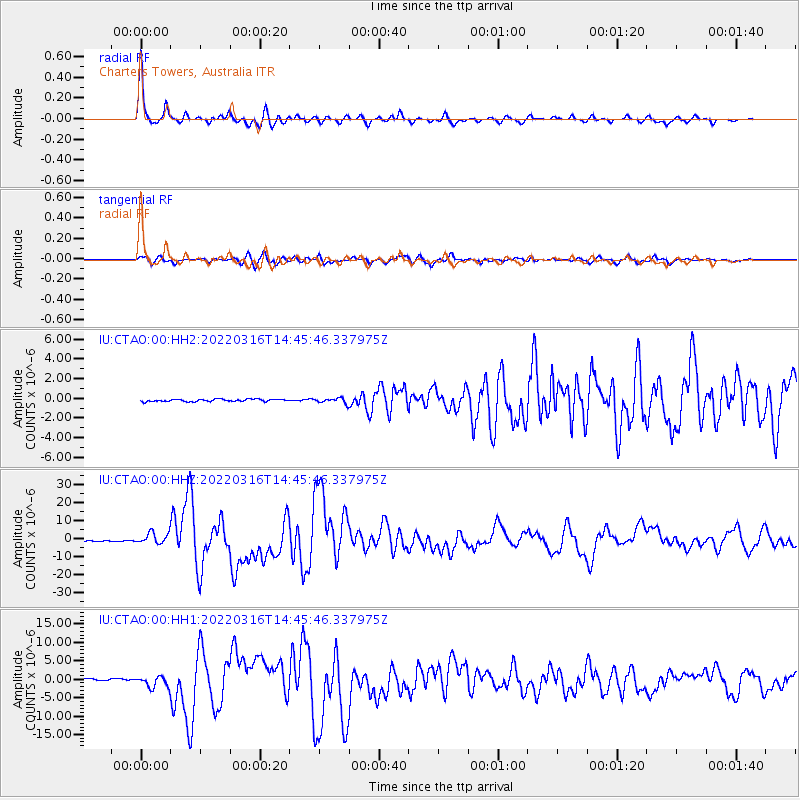
CTAO Charters Towers, Australia - Earthquake Result Viewer

| Earthquake location: |
Near East Coast Of Honshu, Japan |
| Earthquake latitude/longitude: |
37.7/141.6 |
| Earthquake time(UTC): |
2022/03/16 (075) 14:36:33 GMT |
| Earthquake Depth: |
63 km |
| Earthquake Magnitude: |
7.3 mww |
| Earthquake Catalog/Contributor: |
NEIC PDE/us |
|
| Network: |
IU Global Seismograph Network (GSN - IRIS/USGS) |
| Station: |
CTAO Charters Towers, Australia |
| Lat/Lon: |
20.09 S/146.25 E |
| Elevation: |
367 m |
|
| Distance: |
57.6 deg |
| Az: |
174.81 deg |
| Baz: |
355.622 deg |
| Ray Param: |
0.06320147 |
| Estimated Moho Depth: |
35.75 km |
| Estimated Crust Vp/Vs: |
1.74 |
| Assumed Crust Vp: |
6.522 km/s |
| Estimated Crust Vs: |
3.759 km/s |
| Estimated Crust Poisson's Ratio: |
0.25 |
|
| Radial Match: |
98.33199 % |
| Radial Bump: |
344 |
| Transverse Match: |
90.630066 % |
| Transverse Bump: |
400 |
| SOD ConfigId: |
27527651 |
| Insert Time: |
2022-03-30 15:36:17.516 +0000 |
| GWidth: |
2.5 |
| Max Bumps: |
400 |
| Tol: |
0.001 |
|
Signal To Noise
| Channel | StoN | STA | LTA |
| IU:CTAO:00:HHZ:20220316T14:45:46.337975Z | 12.885028 | 3.0989715E-6 | 2.405095E-7 |
| IU:CTAO:00:HH1:20220316T14:45:46.337975Z | 7.2082543 | 1.473923E-6 | 2.044771E-7 |
| IU:CTAO:00:HH2:20220316T14:45:46.337975Z | 2.2737556 | 2.670906E-7 | 1.1746672E-7 |
| Arrivals |
| Ps | 4.2 SECOND |
| PpPs | 14 SECOND |
| PsPs/PpSs | 18 SECOND |


