You are here: Home > Network List > MB - Montana Regional Seismic Network Stations List
> Station HLMT Hummingbird Lane > Earthquake Result Viewer
HLMT Hummingbird Lane - Earthquake Result Viewer
| Earthquake location: |
Near East Coast Of Honshu, Japan |
| Earthquake latitude/longitude: |
37.7/141.6 |
| Earthquake time(UTC): |
2022/03/16 (075) 14:36:33 GMT |
| Earthquake Depth: |
63 km |
| Earthquake Magnitude: |
7.3 mww |
| Earthquake Catalog/Contributor: |
NEIC PDE/us |
|
| Network: |
MB Montana Regional Seismic Network |
| Station: |
HLMT Hummingbird Lane |
| Lat/Lon: |
45.90 N/112.56 W |
| Elevation: |
1843 m |
|
| Distance: |
73.5 deg |
| Az: |
44.482 deg |
| Baz: |
307.259 deg |
| Ray Param: |
0.05285283 |
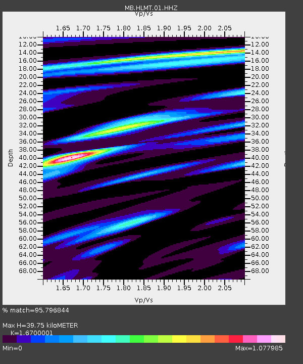
| Estimated Moho Depth: |
39.75 km |
| Estimated Crust Vp/Vs: |
1.67 |
| Assumed Crust Vp: |
6.577 km/s |
| Estimated Crust Vs: |
3.938 km/s |
| Estimated Crust Poisson's Ratio: |
0.22 |
|
| Radial Match: |
95.796844 % |
| Radial Bump: |
398 |
| Transverse Match: |
91.18585 % |
| Transverse Bump: |
400 |
| SOD ConfigId: |
27527651 |
| Insert Time: |
2022-03-30 15:38:21.378 +0000 |
| GWidth: |
2.5 |
| Max Bumps: |
400 |
| Tol: |
0.001 |
|

Signal To Noise
| Channel | StoN | STA | LTA |
| MB:HLMT:01:HHZ:20220316T14:47:28.07003Z | 24.110521 | 5.191749E-6 | 2.1533127E-7 |
| MB:HLMT:01:HHN:20220316T14:47:28.07003Z | 3.7491567 | 1.2109209E-6 | 3.2298487E-7 |
| MB:HLMT:01:HHE:20220316T14:47:28.07003Z | 3.2663321 | 1.8260791E-6 | 5.590611E-7 |
| Arrivals |
| Ps | 4.2 SECOND |
| PpPs | 16 SECOND |
| PsPs/PpSs | 20 SECOND |


