You are here: Home > Network List > N4 - Central and EAstern US Network Stations List
> Station M44A Midewin, Midewin Nat. Tallgrass Prarie, IL, USA > Earthquake Result Viewer
M44A Midewin, Midewin Nat. Tallgrass Prarie, IL, USA - Earthquake Result Viewer
| Earthquake location: |
Near East Coast Of Honshu, Japan |
| Earthquake latitude/longitude: |
37.7/141.6 |
| Earthquake time(UTC): |
2022/03/16 (075) 14:36:33 GMT |
| Earthquake Depth: |
63 km |
| Earthquake Magnitude: |
7.3 mww |
| Earthquake Catalog/Contributor: |
NEIC PDE/us |
|
| Network: |
N4 Central and EAstern US Network |
| Station: |
M44A Midewin, Midewin Nat. Tallgrass Prarie, IL, USA |
| Lat/Lon: |
41.39 N/88.04 W |
| Elevation: |
207 m |
|
| Distance: |
89.2 deg |
| Az: |
34.983 deg |
| Baz: |
322.816 deg |
| Ray Param: |
0.04194017 |
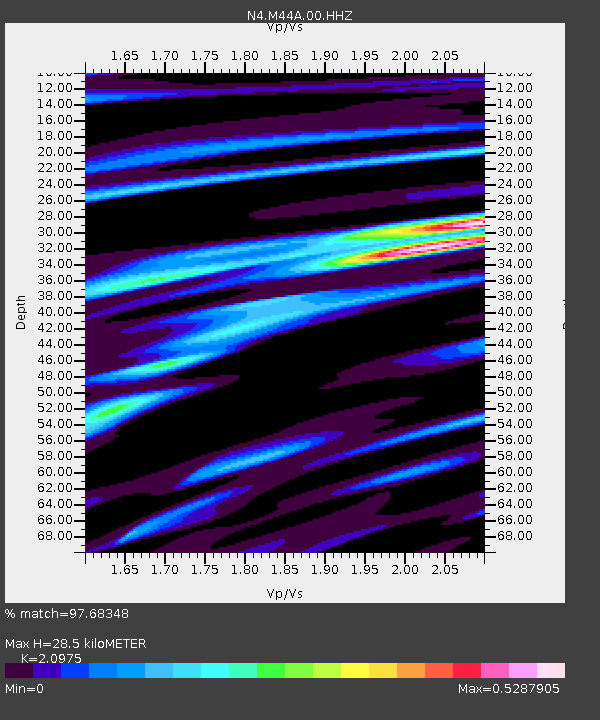
| Estimated Moho Depth: |
28.5 km |
| Estimated Crust Vp/Vs: |
2.10 |
| Assumed Crust Vp: |
6.498 km/s |
| Estimated Crust Vs: |
3.098 km/s |
| Estimated Crust Poisson's Ratio: |
0.35 |
|
| Radial Match: |
97.68348 % |
| Radial Bump: |
357 |
| Transverse Match: |
94.36922 % |
| Transverse Bump: |
388 |
| SOD ConfigId: |
27527651 |
| Insert Time: |
2022-03-30 15:39:44.961 +0000 |
| GWidth: |
2.5 |
| Max Bumps: |
400 |
| Tol: |
0.001 |
|

Signal To Noise
| Channel | StoN | STA | LTA |
| N4:M44A:00:HHZ:20220316T14:48:50.769981Z | 21.530458 | 4.470466E-6 | 2.076345E-7 |
| N4:M44A:00:HH1:20220316T14:48:50.769981Z | 6.9018893 | 1.1785207E-6 | 1.7075335E-7 |
| N4:M44A:00:HH2:20220316T14:48:50.769981Z | 4.3524227 | 9.58566E-7 | 2.2023734E-7 |
| Arrivals |
| Ps | 4.9 SECOND |
| PpPs | 13 SECOND |
| PsPs/PpSs | 18 SECOND |


