You are here: Home > Network List > N4 - Central and EAstern US Network Stations List
> Station R49A Shelbyville, KY, USA > Earthquake Result Viewer
R49A Shelbyville, KY, USA - Earthquake Result Viewer
| Earthquake location: |
Near East Coast Of Honshu, Japan |
| Earthquake latitude/longitude: |
37.7/141.6 |
| Earthquake time(UTC): |
2022/03/16 (075) 14:36:33 GMT |
| Earthquake Depth: |
63 km |
| Earthquake Magnitude: |
7.3 mww |
| Earthquake Catalog/Contributor: |
NEIC PDE/us |
|
| Network: |
N4 Central and EAstern US Network |
| Station: |
R49A Shelbyville, KY, USA |
| Lat/Lon: |
38.29 N/85.17 W |
| Elevation: |
251 m |
|
| Distance: |
93.0 deg |
| Az: |
35.029 deg |
| Baz: |
324.648 deg |
| Ray Param: |
0.041332595 |
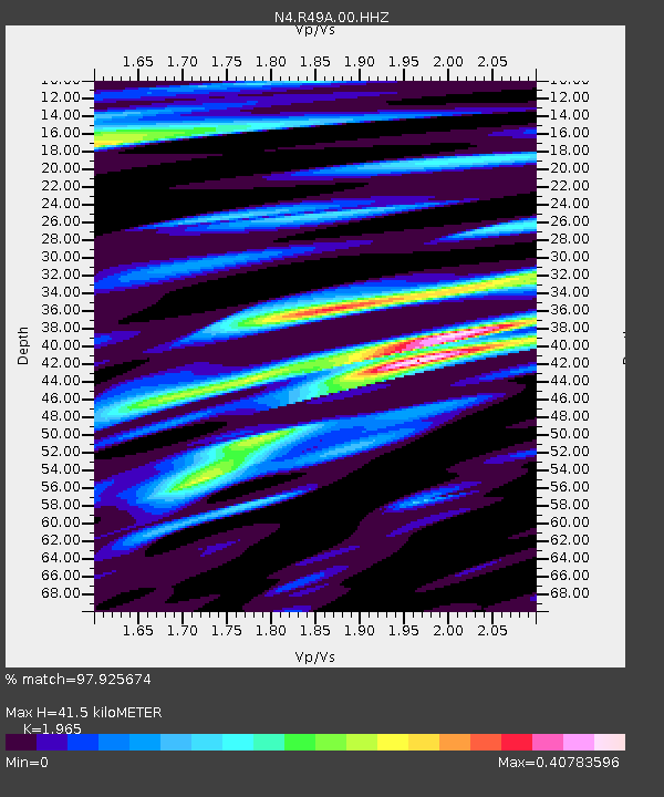
| Estimated Moho Depth: |
41.5 km |
| Estimated Crust Vp/Vs: |
1.97 |
| Assumed Crust Vp: |
6.498 km/s |
| Estimated Crust Vs: |
3.307 km/s |
| Estimated Crust Poisson's Ratio: |
0.33 |
|
| Radial Match: |
97.925674 % |
| Radial Bump: |
371 |
| Transverse Match: |
86.55556 % |
| Transverse Bump: |
400 |
| SOD ConfigId: |
27527651 |
| Insert Time: |
2022-03-30 15:40:24.455 +0000 |
| GWidth: |
2.5 |
| Max Bumps: |
400 |
| Tol: |
0.001 |
|

Signal To Noise
| Channel | StoN | STA | LTA |
| N4:R49A:00:HHZ:20220316T14:49:08.32003Z | 14.120764 | 2.4580042E-6 | 1.740702E-7 |
| N4:R49A:00:HH1:20220316T14:49:08.32003Z | 4.783211 | 4.58145E-7 | 9.5781886E-8 |
| N4:R49A:00:HH2:20220316T14:49:08.32003Z | 2.7021804 | 3.2070275E-7 | 1.1868296E-7 |
| Arrivals |
| Ps | 6.3 SECOND |
| PpPs | 19 SECOND |
| PsPs/PpSs | 25 SECOND |


