You are here: Home > Network List > O2 - Oklahoma Consolidated Temporary Seismic Networks Stations List
> Station SC20 Lookeba, Oklahoma, USA > Earthquake Result Viewer
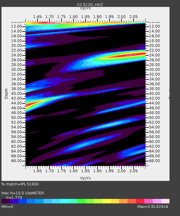
SC20 Lookeba, Oklahoma, USA - Earthquake Result Viewer
| Earthquake location: |
Near East Coast Of Honshu, Japan |
| Earthquake latitude/longitude: |
37.7/141.6 |
| Earthquake time(UTC): |
2022/03/16 (075) 14:36:33 GMT |
| Earthquake Depth: |
63 km |
| Earthquake Magnitude: |
7.3 mww |
| Earthquake Catalog/Contributor: |
NEIC PDE/us |
|
| Network: |
O2 Oklahoma Consolidated Temporary Seismic Networks |
| Station: |
SC20 Lookeba, Oklahoma, USA |
| Lat/Lon: |
35.40 N/98.44 W |
| Elevation: |
490 m |
|
| Distance: |
88.4 deg |
| Az: |
45.068 deg |
| Baz: |
316.577 deg |
| Ray Param: |
0.042481728 |
| Estimated Moho Depth: |
10.0 km |
| Estimated Crust Vp/Vs: |
1.77 |
| Assumed Crust Vp: |
6.315 km/s |
| Estimated Crust Vs: |
3.558 km/s |
| Estimated Crust Poisson's Ratio: |
0.27 |
|
| Radial Match: |
95.51808 % |
| Radial Bump: |
400 |
| Transverse Match: |
92.45846 % |
| Transverse Bump: |
400 |
| SOD ConfigId: |
27527651 |
| Insert Time: |
2022-03-30 15:44:45.391 +0000 |
| GWidth: |
2.5 |
| Max Bumps: |
400 |
| Tol: |
0.001 |
|

Signal To Noise
| Channel | StoN | STA | LTA |
| O2:SC20: :HHZ:20220316T14:48:47.290001Z | 15.9999 | 3.6517315E-6 | 2.2823464E-7 |
| O2:SC20: :HHN:20220316T14:48:47.290001Z | 1.9884657 | 5.8236003E-7 | 2.9286903E-7 |
| O2:SC20: :HHE:20220316T14:48:47.290001Z | 2.2623656 | 8.886155E-7 | 3.9278157E-7 |
| Arrivals |
| Ps | 1.3 SECOND |
| PpPs | 4.3 SECOND |
| PsPs/PpSs | 5.6 SECOND |


