You are here: Home > Network List > SB - UC Santa Barbara Engineering Seismology Network () Stations List
> Station VAFB2 Taft Rd, Vandenberg AFB, CA, USA > Earthquake Result Viewer
VAFB2 Taft Rd, Vandenberg AFB, CA, USA - Earthquake Result Viewer
| Earthquake location: |
Near East Coast Of Honshu, Japan |
| Earthquake latitude/longitude: |
37.7/141.6 |
| Earthquake time(UTC): |
2022/03/16 (075) 14:36:33 GMT |
| Earthquake Depth: |
63 km |
| Earthquake Magnitude: |
7.3 mww |
| Earthquake Catalog/Contributor: |
NEIC PDE/us |
|
| Network: |
SB UC Santa Barbara Engineering Seismology Network () |
| Station: |
VAFB2 Taft Rd, Vandenberg AFB, CA, USA |
| Lat/Lon: |
34.84 N/120.58 W |
| Elevation: |
91 m |
|
| Distance: |
75.1 deg |
| Az: |
57.486 deg |
| Baz: |
305.589 deg |
| Ray Param: |
0.051780365 |
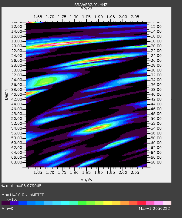
| Estimated Moho Depth: |
10.0 km |
| Estimated Crust Vp/Vs: |
1.60 |
| Assumed Crust Vp: |
6.183 km/s |
| Estimated Crust Vs: |
3.864 km/s |
| Estimated Crust Poisson's Ratio: |
0.18 |
|
| Radial Match: |
86.979065 % |
| Radial Bump: |
400 |
| Transverse Match: |
82.12081 % |
| Transverse Bump: |
400 |
| SOD ConfigId: |
27527651 |
| Insert Time: |
2022-03-30 15:49:03.290 +0000 |
| GWidth: |
2.5 |
| Max Bumps: |
400 |
| Tol: |
0.001 |
|

Signal To Noise
| Channel | StoN | STA | LTA |
| SB:VAFB2:01:HHZ:20220316T14:47:37.415001Z | 3.4887547 | 3.8656526E-6 | 1.1080322E-6 |
| SB:VAFB2:01:HHN:20220316T14:47:37.415001Z | 1.1662967 | 1.3856984E-6 | 1.1881182E-6 |
| SB:VAFB2:01:HHE:20220316T14:47:37.415001Z | 1.9722831 | 2.4491242E-6 | 1.2417711E-6 |
| Arrivals |
| Ps | 1.0 SECOND |
| PpPs | 4.1 SECOND |
| PsPs/PpSs | 5.1 SECOND |


