You are here: Home > Network List > TX - Texas Seismological Network Stations List
> Station ET01 Chireno > Earthquake Result Viewer
ET01 Chireno - Earthquake Result Viewer
| Earthquake location: |
Near East Coast Of Honshu, Japan |
| Earthquake latitude/longitude: |
37.7/141.6 |
| Earthquake time(UTC): |
2022/03/16 (075) 14:36:33 GMT |
| Earthquake Depth: |
63 km |
| Earthquake Magnitude: |
7.3 mww |
| Earthquake Catalog/Contributor: |
NEIC PDE/us |
|
| Network: |
TX Texas Seismological Network |
| Station: |
ET01 Chireno |
| Lat/Lon: |
31.46 N/94.37 W |
| Elevation: |
127 m |
|
| Distance: |
93.6 deg |
| Az: |
45.19 deg |
| Baz: |
318.812 deg |
| Ray Param: |
0.04119628 |
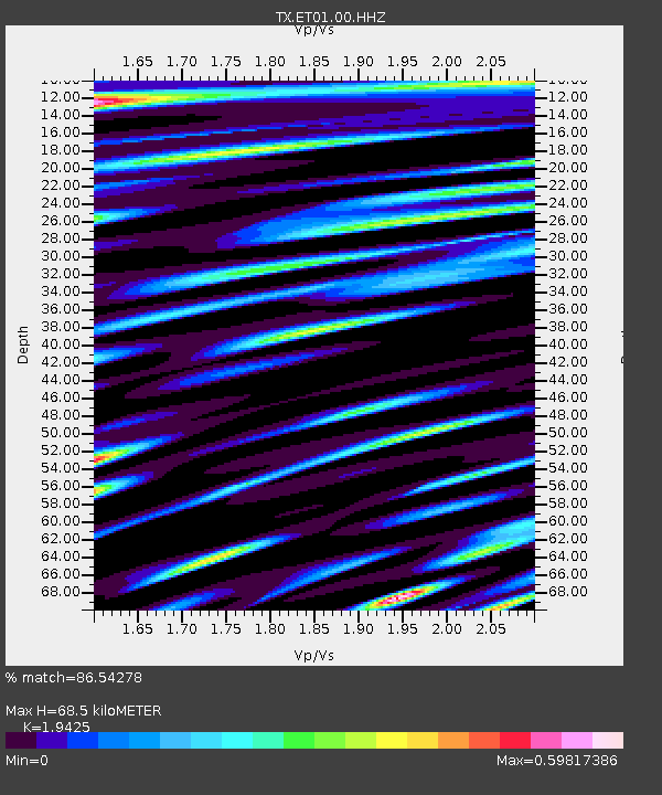
| Estimated Moho Depth: |
68.5 km |
| Estimated Crust Vp/Vs: |
1.94 |
| Assumed Crust Vp: |
5.738 km/s |
| Estimated Crust Vs: |
2.954 km/s |
| Estimated Crust Poisson's Ratio: |
0.32 |
|
| Radial Match: |
86.54278 % |
| Radial Bump: |
400 |
| Transverse Match: |
82.3689 % |
| Transverse Bump: |
400 |
| SOD ConfigId: |
27527651 |
| Insert Time: |
2022-03-30 15:49:59.088 +0000 |
| GWidth: |
2.5 |
| Max Bumps: |
400 |
| Tol: |
0.001 |
|

Signal To Noise
| Channel | StoN | STA | LTA |
| TX:ET01:00:HHZ:20220316T14:49:11.310021Z | 9.424757 | 1.5666582E-6 | 1.6622798E-7 |
| TX:ET01:00:HH1:20220316T14:49:11.310021Z | 1.9554716 | 4.078864E-7 | 2.0858722E-7 |
| TX:ET01:00:HH2:20220316T14:49:11.310021Z | 0.5277756 | 1.68625E-7 | 3.195013E-7 |
| Arrivals |
| Ps | 11 SECOND |
| PpPs | 35 SECOND |
| PsPs/PpSs | 46 SECOND |


