You are here: Home > Network List > US - United States National Seismic Network Stations List
> Station WUAZ Wupatki, Arizona, USA > Earthquake Result Viewer
WUAZ Wupatki, Arizona, USA - Earthquake Result Viewer

| Earthquake location: |
Near East Coast Of Honshu, Japan |
| Earthquake latitude/longitude: |
37.7/141.6 |
| Earthquake time(UTC): |
2022/03/16 (075) 14:36:33 GMT |
| Earthquake Depth: |
63 km |
| Earthquake Magnitude: |
7.3 mww |
| Earthquake Catalog/Contributor: |
NEIC PDE/us |
|
| Network: |
US United States National Seismic Network |
| Station: |
WUAZ Wupatki, Arizona, USA |
| Lat/Lon: |
35.52 N/111.37 W |
| Elevation: |
1592 m |
|
| Distance: |
80.6 deg |
| Az: |
52.232 deg |
| Baz: |
309.772 deg |
| Ray Param: |
0.048017353 |
| Estimated Moho Depth: |
11.5 km |
| Estimated Crust Vp/Vs: |
2.10 |
| Assumed Crust Vp: |
6.207 km/s |
| Estimated Crust Vs: |
2.959 km/s |
| Estimated Crust Poisson's Ratio: |
0.35 |
|
| Radial Match: |
94.11709 % |
| Radial Bump: |
400 |
| Transverse Match: |
85.19127 % |
| Transverse Bump: |
400 |
| SOD ConfigId: |
27527651 |
| Insert Time: |
2022-03-30 15:54:09.436 +0000 |
| GWidth: |
2.5 |
| Max Bumps: |
400 |
| Tol: |
0.001 |
|
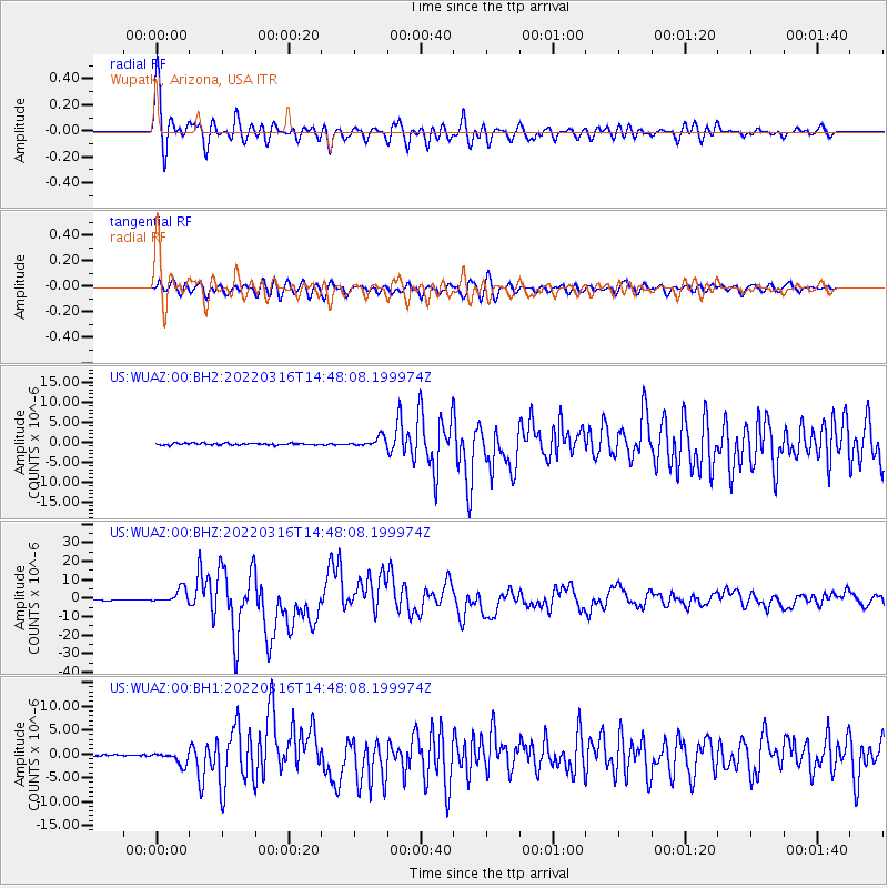
Signal To Noise
| Channel | StoN | STA | LTA |
| US:WUAZ:00:BHZ:20220316T14:48:08.199974Z | 18.428837 | 3.878526E-6 | 2.1045963E-7 |
| US:WUAZ:00:BH1:20220316T14:48:08.199974Z | 6.8867836 | 1.270007E-6 | 1.8441222E-7 |
| US:WUAZ:00:BH2:20220316T14:48:08.199974Z | 5.220243 | 1.1991696E-6 | 2.2971528E-7 |
| Arrivals |
| Ps | 2.1 SECOND |
| PpPs | 5.6 SECOND |
| PsPs/PpSs | 7.7 SECOND |


