You are here: Home > Network List > UW - Pacific Northwest Regional Seismic Network Stations List
> Station BABR Pacific Northwest Seismic Network > Earthquake Result Viewer
BABR Pacific Northwest Seismic Network - Earthquake Result Viewer
| Earthquake location: |
Near East Coast Of Honshu, Japan |
| Earthquake latitude/longitude: |
37.7/141.6 |
| Earthquake time(UTC): |
2022/03/16 (075) 14:36:33 GMT |
| Earthquake Depth: |
63 km |
| Earthquake Magnitude: |
7.3 mww |
| Earthquake Catalog/Contributor: |
NEIC PDE/us |
|
| Network: |
UW Pacific Northwest Regional Seismic Network |
| Station: |
BABR Pacific Northwest Seismic Network |
| Lat/Lon: |
44.62 N/123.79 W |
| Elevation: |
439 m |
|
| Distance: |
67.6 deg |
| Az: |
50.33 deg |
| Baz: |
301.244 deg |
| Ray Param: |
0.056699947 |
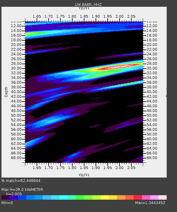
| Estimated Moho Depth: |
29.0 km |
| Estimated Crust Vp/Vs: |
2.01 |
| Assumed Crust Vp: |
6.566 km/s |
| Estimated Crust Vs: |
3.275 km/s |
| Estimated Crust Poisson's Ratio: |
0.33 |
|
| Radial Match: |
92.449844 % |
| Radial Bump: |
397 |
| Transverse Match: |
77.89211 % |
| Transverse Bump: |
400 |
| SOD ConfigId: |
27527651 |
| Insert Time: |
2022-03-30 15:54:31.814 +0000 |
| GWidth: |
2.5 |
| Max Bumps: |
400 |
| Tol: |
0.001 |
|

Signal To Noise
| Channel | StoN | STA | LTA |
| UW:BABR: :HHZ:20220316T14:46:52.630028Z | 3.072317 | 4.2173847E-6 | 1.372705E-6 |
| UW:BABR: :HHN:20220316T14:46:52.630028Z | 0.6740053 | 1.0585131E-6 | 1.5704819E-6 |
| UW:BABR: :HHE:20220316T14:46:52.630028Z | 1.0146092 | 1.2541065E-6 | 1.2360487E-6 |
| Arrivals |
| Ps | 4.6 SECOND |
| PpPs | 13 SECOND |
| PsPs/PpSs | 17 SECOND |


