You are here: Home > Network List > UW - Pacific Northwest Regional Seismic Network Stations List
> Station LTY Liberty (broad-band) > Earthquake Result Viewer
LTY Liberty (broad-band) - Earthquake Result Viewer
| Earthquake location: |
Near East Coast Of Honshu, Japan |
| Earthquake latitude/longitude: |
37.7/141.6 |
| Earthquake time(UTC): |
2022/03/16 (075) 14:36:33 GMT |
| Earthquake Depth: |
63 km |
| Earthquake Magnitude: |
7.3 mww |
| Earthquake Catalog/Contributor: |
NEIC PDE/us |
|
| Network: |
UW Pacific Northwest Regional Seismic Network |
| Station: |
LTY Liberty (broad-band) |
| Lat/Lon: |
47.26 N/120.66 W |
| Elevation: |
970 m |
|
| Distance: |
68.1 deg |
| Az: |
46.674 deg |
| Baz: |
302.105 deg |
| Ray Param: |
0.05638584 |
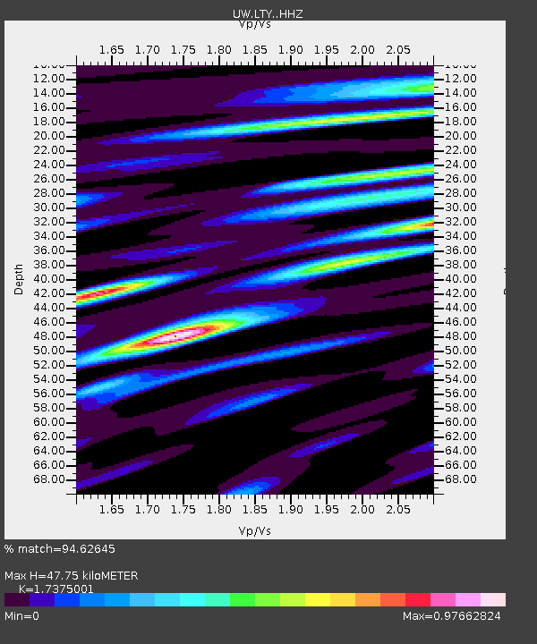
| Estimated Moho Depth: |
47.75 km |
| Estimated Crust Vp/Vs: |
1.74 |
| Assumed Crust Vp: |
6.597 km/s |
| Estimated Crust Vs: |
3.797 km/s |
| Estimated Crust Poisson's Ratio: |
0.25 |
|
| Radial Match: |
94.62645 % |
| Radial Bump: |
400 |
| Transverse Match: |
87.89269 % |
| Transverse Bump: |
400 |
| SOD ConfigId: |
27527651 |
| Insert Time: |
2022-03-30 15:55:38.686 +0000 |
| GWidth: |
2.5 |
| Max Bumps: |
400 |
| Tol: |
0.001 |
|

Signal To Noise
| Channel | StoN | STA | LTA |
| UW:LTY: :HHZ:20220316T14:46:55.589989Z | 8.652524 | 3.9311167E-6 | 4.543318E-7 |
| UW:LTY: :HHN:20220316T14:46:55.589989Z | 3.9853 | 1.1124539E-6 | 2.7913933E-7 |
| UW:LTY: :HHE:20220316T14:46:55.589989Z | 2.663064 | 9.849225E-7 | 3.698456E-7 |
| Arrivals |
| Ps | 5.6 SECOND |
| PpPs | 19 SECOND |
| PsPs/PpSs | 25 SECOND |


