You are here: Home > Network List > YX16 - Raton Basin UNM Broadband Network Stations List
> Station UNM2 SE Corner of NM Stations > Earthquake Result Viewer
UNM2 SE Corner of NM Stations - Earthquake Result Viewer
| Earthquake location: |
Near East Coast Of Honshu, Japan |
| Earthquake latitude/longitude: |
37.7/141.6 |
| Earthquake time(UTC): |
2022/03/16 (075) 14:36:33 GMT |
| Earthquake Depth: |
63 km |
| Earthquake Magnitude: |
7.3 mww |
| Earthquake Catalog/Contributor: |
NEIC PDE/us |
|
| Network: |
YX Raton Basin UNM Broadband Network |
| Station: |
UNM2 SE Corner of NM Stations |
| Lat/Lon: |
36.80 N/104.86 W |
| Elevation: |
2166 m |
|
| Distance: |
83.7 deg |
| Az: |
47.747 deg |
| Baz: |
312.99 deg |
| Ray Param: |
0.045846727 |
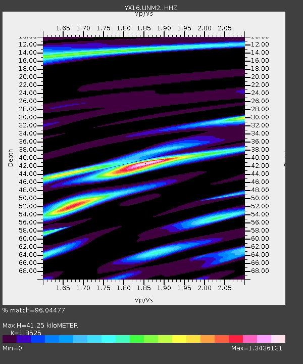
| Estimated Moho Depth: |
41.25 km |
| Estimated Crust Vp/Vs: |
1.85 |
| Assumed Crust Vp: |
6.316 km/s |
| Estimated Crust Vs: |
3.409 km/s |
| Estimated Crust Poisson's Ratio: |
0.29 |
|
| Radial Match: |
96.04477 % |
| Radial Bump: |
400 |
| Transverse Match: |
93.55863 % |
| Transverse Bump: |
382 |
| SOD ConfigId: |
27527651 |
| Insert Time: |
2022-03-30 15:59:00.732 +0000 |
| GWidth: |
2.5 |
| Max Bumps: |
400 |
| Tol: |
0.001 |
|

Signal To Noise
| Channel | StoN | STA | LTA |
| YX:UNM2: :HHZ:20220316T14:48:24.36898Z | 19.279917 | 4.8408992E-6 | 2.5108508E-7 |
| YX:UNM2: :HHN:20220316T14:48:24.36898Z | 6.896334 | 1.0402487E-6 | 1.508408E-7 |
| YX:UNM2: :HHE:20220316T14:48:24.36898Z | 5.7896876 | 1.0226306E-6 | 1.7662967E-7 |
| Arrivals |
| Ps | 5.7 SECOND |
| PpPs | 18 SECOND |
| PsPs/PpSs | 24 SECOND |


