You are here: Home > Network List > XE05 - Sierra Nevada EarthScope Project- EarthScope Flex Array Stations List
> Station SNP97 SNP97 > Earthquake Result Viewer
SNP97 SNP97 - Earthquake Result Viewer
| Earthquake location: |
Andreanof Islands, Aleutian Is. |
| Earthquake latitude/longitude: |
52.0/-180.0 |
| Earthquake time(UTC): |
2007/04/29 (119) 12:41:57 GMT |
| Earthquake Depth: |
117 km |
| Earthquake Magnitude: |
6.2 MB, 6.2 MW, 6.2 MW |
| Earthquake Catalog/Contributor: |
WHDF/NEIC |
|
| Network: |
XE Sierra Nevada EarthScope Project- EarthScope Flex Array |
| Station: |
SNP97 SNP97 |
| Lat/Lon: |
38.81 N/119.81 W |
| Elevation: |
1770 m |
|
| Distance: |
43.0 deg |
| Az: |
83.244 deg |
| Baz: |
308.217 deg |
| Ray Param: |
0.0723842 |
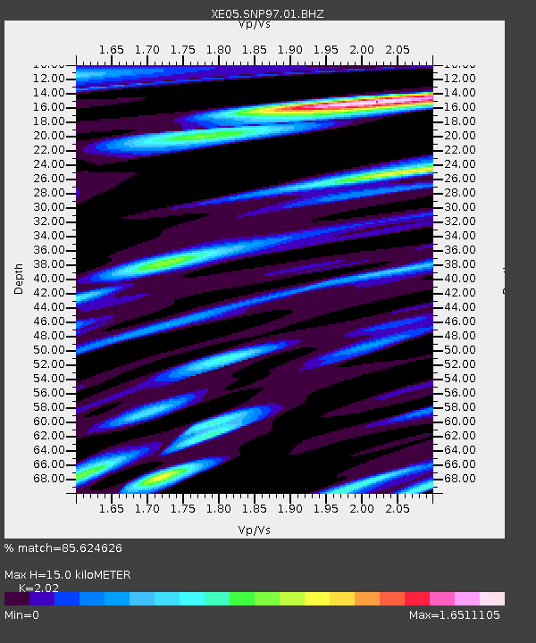
| Estimated Moho Depth: |
15.0 km |
| Estimated Crust Vp/Vs: |
2.02 |
| Assumed Crust Vp: |
6.279 km/s |
| Estimated Crust Vs: |
3.108 km/s |
| Estimated Crust Poisson's Ratio: |
0.34 |
|
| Radial Match: |
85.624626 % |
| Radial Bump: |
400 |
| Transverse Match: |
86.481834 % |
| Transverse Bump: |
400 |
| SOD ConfigId: |
268666 |
| Insert Time: |
2010-03-09 17:39:20.966 +0000 |
| GWidth: |
2.5 |
| Max Bumps: |
400 |
| Tol: |
0.001 |
|

Signal To Noise
| Channel | StoN | STA | LTA |
| XE:SNP97:01:BHZ:20070429T12:49:15.015Z | 100.04922 | 1.504448E-5 | 1.503708E-7 |
| XE:SNP97:01:BHN:20070429T12:49:15.015Z | 18.647291 | 4.9250166E-6 | 2.641143E-7 |
| XE:SNP97:01:BHE:20070429T12:49:15.015Z | 8.828813 | 3.150032E-6 | 3.5678997E-7 |
| Arrivals |
| Ps | 2.6 SECOND |
| PpPs | 6.8 SECOND |
| PsPs/PpSs | 9.4 SECOND |


