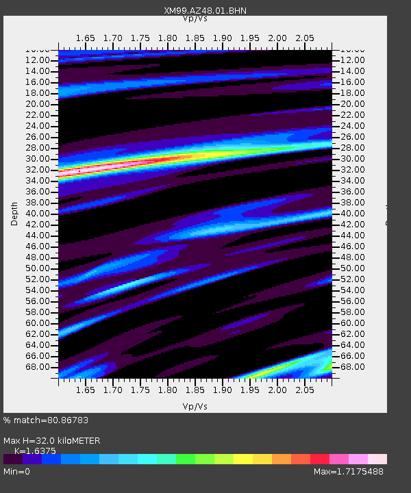
AZ48 Arizona48 - Earthquake Result Viewer

Earthquake location: Near Coast Of Northern Peru
Earthquake latitude/longitude: -4.1/-81.1
Earthquake time(UTC): 2000/05/22 (143) 13:15:08 GMT
Earthquake Depth: 33 km
Earthquake Magnitude: 5.3 MB, 5.4 MS, 5.8 MW, 5.8 MW
Earthquake Catalog/Contributor: WHDF/NEIC
Network: XM Rio Grande Seismic Transect
Station: AZ48 Arizona48
Lat/Lon: 36.76 N/109.54 W
Elevation: 1664 m
Distance: 48.5 deg
Az: 329.312 deg
Baz: 140.66 deg
Ray Param: 0.06922619
Estimated Moho Depth: 32.0 km
Estimated Crust Vp/Vs: 1.64
Assumed Crust Vp: 6.476 km/s
Estimated Crust Vs: 3.955 km/s
Estimated Crust Poisson's Ratio: 0.20
Radial Match: 80.86783 %
Radial Bump: 400
Transverse Match: 64.38637 %
Transverse Bump: 400
SOD ConfigId: 27569
Insert Time: 2010-02-26 17:18:34.845 +0000
GWidth: 2.5
Max Bumps: 400
Tol: 0.001

Signal To Noise

ChannelStoNSTALTA
XM:AZ48:01:BHN:20000522T13:23:18.324014Z1.08783268.319598E-87.6478656E-8
XM:AZ48:01:BHE:20000522T13:23:18.324014Z1.15293539.2716654E-88.041792E-8
XM:AZ48:01:BHZ:20000522T13:23:18.324014Z1.86048511.422508E-77.645898E-8
Arrivals
Ps3.4 SECOND
PpPs12 SECOND
PsPs/PpSs16 SECOND