You are here: Home > Network List > US - United States National Seismic Network Stations List
> Station LAO LASA Array, Montana, USA > Earthquake Result Viewer
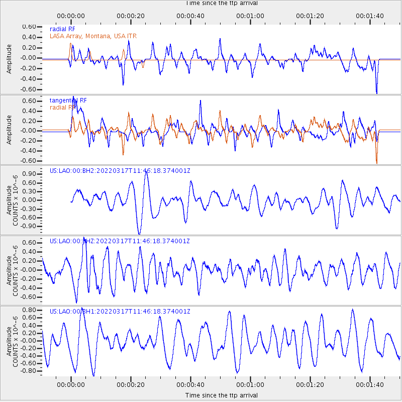
LAO LASA Array, Montana, USA - Earthquake Result Viewer
*The percent match for this event was below the threshold and hence no stack was calculated.
| Earthquake location: |
Ryukyu Islands, Japan |
| Earthquake latitude/longitude: |
26.8/126.4 |
| Earthquake time(UTC): |
2022/03/17 (076) 11:33:37 GMT |
| Earthquake Depth: |
10 km |
| Earthquake Magnitude: |
5.6 mww |
| Earthquake Catalog/Contributor: |
NEIC PDE/us |
|
| Network: |
US United States National Seismic Network |
| Station: |
LAO LASA Array, Montana, USA |
| Lat/Lon: |
46.69 N/106.22 W |
| Elevation: |
902 m |
|
| Distance: |
92.8 deg |
| Az: |
33.198 deg |
| Baz: |
314.699 deg |
| Ray Param: |
$rayparam |
*The percent match for this event was below the threshold and hence was not used in the summary stack. |
|
| Radial Match: |
55.878113 % |
| Radial Bump: |
400 |
| Transverse Match: |
65.274414 % |
| Transverse Bump: |
400 |
| SOD ConfigId: |
27527651 |
| Insert Time: |
2022-03-31 11:51:42.130 +0000 |
| GWidth: |
2.5 |
| Max Bumps: |
400 |
| Tol: |
0.001 |
|
Signal To Noise
| Channel | StoN | STA | LTA |
| US:LAO:00:BHZ:20220317T11:46:18.374001Z | 3.103867 | 4.039347E-7 | 1.3013917E-7 |
| US:LAO:00:BH1:20220317T11:46:18.374001Z | 2.1869025 | 5.871877E-7 | 2.68502E-7 |
| US:LAO:00:BH2:20220317T11:46:18.374001Z | 0.5433893 | 1.9845972E-7 | 3.6522565E-7 |
| Arrivals |
| Ps | |
| PpPs | |
| PsPs/PpSs | |


