You are here: Home > Network List > US - United States National Seismic Network Stations List
> Station MSO Missoula, Montana, USA > Earthquake Result Viewer
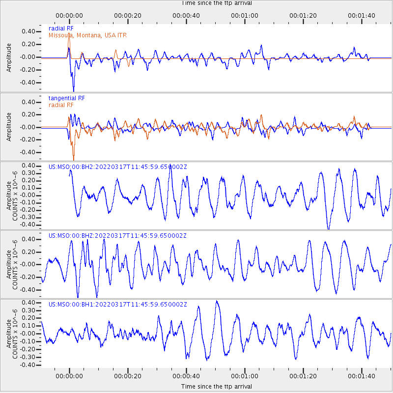
MSO Missoula, Montana, USA - Earthquake Result Viewer
*The percent match for this event was below the threshold and hence no stack was calculated.
| Earthquake location: |
Ryukyu Islands, Japan |
| Earthquake latitude/longitude: |
26.8/126.4 |
| Earthquake time(UTC): |
2022/03/17 (076) 11:33:37 GMT |
| Earthquake Depth: |
10 km |
| Earthquake Magnitude: |
5.6 mww |
| Earthquake Catalog/Contributor: |
NEIC PDE/us |
|
| Network: |
US United States National Seismic Network |
| Station: |
MSO Missoula, Montana, USA |
| Lat/Lon: |
46.83 N/113.94 W |
| Elevation: |
1264 m |
|
| Distance: |
88.7 deg |
| Az: |
36.634 deg |
| Baz: |
309.046 deg |
| Ray Param: |
$rayparam |
*The percent match for this event was below the threshold and hence was not used in the summary stack. |
|
| Radial Match: |
53.965767 % |
| Radial Bump: |
400 |
| Transverse Match: |
51.52425 % |
| Transverse Bump: |
400 |
| SOD ConfigId: |
27527651 |
| Insert Time: |
2022-03-31 11:51:45.040 +0000 |
| GWidth: |
2.5 |
| Max Bumps: |
400 |
| Tol: |
0.001 |
|
Signal To Noise
| Channel | StoN | STA | LTA |
| US:MSO:00:BHZ:20220317T11:45:59.650002Z | 1.7989103 | 2.6830273E-7 | 1.4914737E-7 |
| US:MSO:00:BH1:20220317T11:45:59.650002Z | 0.22150917 | 4.5433143E-8 | 2.0510728E-7 |
| US:MSO:00:BH2:20220317T11:45:59.650002Z | 1.7563212 | 2.2340416E-7 | 1.2720005E-7 |
| Arrivals |
| Ps | |
| PpPs | |
| PsPs/PpSs | |


