You are here: Home > Network List > XE05 - Sierra Nevada EarthScope Project- EarthScope Flex Array Stations List
> Station SNP98 SNP98 > Earthquake Result Viewer
SNP98 SNP98 - Earthquake Result Viewer
| Earthquake location: |
Pacific-Antarctic Ridge |
| Earthquake latitude/longitude: |
-55.1/-129.4 |
| Earthquake time(UTC): |
2007/07/21 (202) 20:40:53 GMT |
| Earthquake Depth: |
10 km |
| Earthquake Magnitude: |
5.7 MW, 5.2 MS, 5.1 MB |
| Earthquake Catalog/Contributor: |
WHDF/NEIC |
|
| Network: |
XE Sierra Nevada EarthScope Project- EarthScope Flex Array |
| Station: |
SNP98 SNP98 |
| Lat/Lon: |
38.92 N/119.42 W |
| Elevation: |
1521 m |
|
| Distance: |
94.0 deg |
| Az: |
7.806 deg |
| Baz: |
185.744 deg |
| Ray Param: |
0.041138288 |
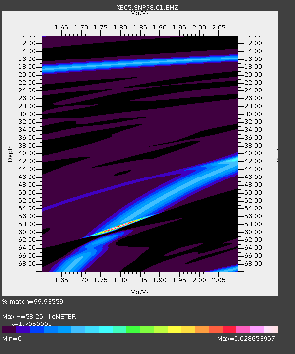
| Estimated Moho Depth: |
58.25 km |
| Estimated Crust Vp/Vs: |
1.80 |
| Assumed Crust Vp: |
6.279 km/s |
| Estimated Crust Vs: |
3.498 km/s |
| Estimated Crust Poisson's Ratio: |
0.27 |
|
| Radial Match: |
99.93559 % |
| Radial Bump: |
8 |
| Transverse Match: |
99.92752 % |
| Transverse Bump: |
10 |
| SOD ConfigId: |
268666 |
| Insert Time: |
2010-03-09 17:42:34.530 +0000 |
| GWidth: |
2.5 |
| Max Bumps: |
400 |
| Tol: |
0.001 |
|

Signal To Noise
| Channel | StoN | STA | LTA |
| XE:SNP98:01:BHZ:20070721T20:53:40.375022Z | 1.702782 | 4.5954707E-6 | 2.6988014E-6 |
| XE:SNP98:01:BHN:20070721T20:53:40.375022Z | 1.707823 | 7.706937E-6 | 4.512726E-6 |
| XE:SNP98:01:BHE:20070721T20:53:40.375022Z | 1.6974009 | 1.1571315E-5 | 6.817078E-6 |
| Arrivals |
| Ps | 7.5 SECOND |
| PpPs | 25 SECOND |
| PsPs/PpSs | 33 SECOND |


