You are here: Home > Network List > US - United States National Seismic Network Stations List
> Station AMTX Amarillo, Texas, USA > Earthquake Result Viewer
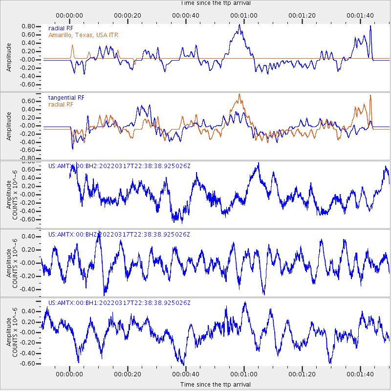
AMTX Amarillo, Texas, USA - Earthquake Result Viewer
*The percent match for this event was below the threshold and hence no stack was calculated.
| Earthquake location: |
Ascension Island Region |
| Earthquake latitude/longitude: |
-11.5/-13.0 |
| Earthquake time(UTC): |
2022/03/17 (076) 22:25:46 GMT |
| Earthquake Depth: |
10 km |
| Earthquake Magnitude: |
5.5 Mww |
| Earthquake Catalog/Contributor: |
NEIC PDE/us |
|
| Network: |
US United States National Seismic Network |
| Station: |
AMTX Amarillo, Texas, USA |
| Lat/Lon: |
34.53 N/101.41 W |
| Elevation: |
1010 m |
|
| Distance: |
95.1 deg |
| Az: |
304.046 deg |
| Baz: |
100.3 deg |
| Ray Param: |
$rayparam |
*The percent match for this event was below the threshold and hence was not used in the summary stack. |
|
| Radial Match: |
23.448833 % |
| Radial Bump: |
400 |
| Transverse Match: |
56.260315 % |
| Transverse Bump: |
400 |
| SOD ConfigId: |
27527651 |
| Insert Time: |
2022-03-31 22:41:14.319 +0000 |
| GWidth: |
2.5 |
| Max Bumps: |
400 |
| Tol: |
0.001 |
|
Signal To Noise
| Channel | StoN | STA | LTA |
| US:AMTX:00:BHZ:20220317T22:38:38.925026Z | 0.7309051 | 1.365565E-7 | 1.8683203E-7 |
| US:AMTX:00:BH1:20220317T22:38:38.925026Z | 0.78445804 | 2.3068644E-7 | 2.940711E-7 |
| US:AMTX:00:BH2:20220317T22:38:38.925026Z | 0.96329564 | 2.3600073E-7 | 2.4499303E-7 |
| Arrivals |
| Ps | |
| PpPs | |
| PsPs/PpSs | |


