You are here: Home > Network List > G - GEOSCOPE Stations List
> Station NOUC Port Laguerre, New Caledonia > Earthquake Result Viewer
NOUC Port Laguerre, New Caledonia - Earthquake Result Viewer
| Earthquake location: |
Near East Coast Of Kamchatka |
| Earthquake latitude/longitude: |
51.6/157.9 |
| Earthquake time(UTC): |
2018/07/06 (187) 01:40:08 GMT |
| Earthquake Depth: |
80 km |
| Earthquake Magnitude: |
6.1 Mwp |
| Earthquake Catalog/Contributor: |
NEIC PDE/us |
|
| Network: |
G GEOSCOPE |
| Station: |
NOUC Port Laguerre, New Caledonia |
| Lat/Lon: |
22.10 S/166.30 E |
| Elevation: |
112 m |
|
| Distance: |
73.8 deg |
| Az: |
171.841 deg |
| Baz: |
354.525 deg |
| Ray Param: |
0.052602615 |
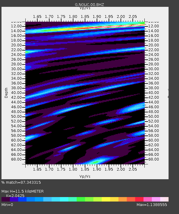
| Estimated Moho Depth: |
11.5 km |
| Estimated Crust Vp/Vs: |
2.04 |
| Assumed Crust Vp: |
5.14 km/s |
| Estimated Crust Vs: |
2.517 km/s |
| Estimated Crust Poisson's Ratio: |
0.34 |
|
| Radial Match: |
87.343315 % |
| Radial Bump: |
400 |
| Transverse Match: |
84.96951 % |
| Transverse Bump: |
400 |
| SOD ConfigId: |
2752131 |
| Insert Time: |
2018-07-20 01:48:22.699 +0000 |
| GWidth: |
2.5 |
| Max Bumps: |
400 |
| Tol: |
0.001 |
|

Signal To Noise
| Channel | StoN | STA | LTA |
| G:NOUC:00:BHZ:20180706T01:51:03.150022Z | 18.114737 | 4.7492063E-6 | 2.6217364E-7 |
| G:NOUC:00:BHN:20180706T01:51:03.150022Z | 5.260127 | 1.6648075E-6 | 3.164957E-7 |
| G:NOUC:00:BHE:20180706T01:51:03.150022Z | 3.414543 | 1.0321561E-6 | 3.0228236E-7 |
| Arrivals |
| Ps | 2.4 SECOND |
| PpPs | 6.7 SECOND |
| PsPs/PpSs | 9.1 SECOND |


