You are here: Home > Network List > XM99 - Rio Grande Seismic Transect Stations List
> Station AZ48 Arizona48 > Earthquake Result Viewer
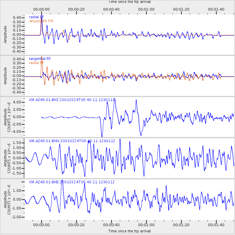
AZ48 Arizona48 - Earthquake Result Viewer

| Earthquake location: |
Western Honshu, Japan |
| Earthquake latitude/longitude: |
34.1/132.5 |
| Earthquake time(UTC): |
2001/03/24 (083) 06:27:53 GMT |
| Earthquake Depth: |
50 km |
| Earthquake Magnitude: |
6.4 MB, 6.5 MS, 6.8 MW, 6.4 ME |
| Earthquake Catalog/Contributor: |
WHDF/NEIC |
|
| Network: |
XM Rio Grande Seismic Transect |
| Station: |
AZ48 Arizona48 |
| Lat/Lon: |
36.76 N/109.54 W |
| Elevation: |
1664 m |
|
| Distance: |
88.8 deg |
| Az: |
45.205 deg |
| Baz: |
312.827 deg |
| Ray Param: |
0.04220144 |
| Estimated Moho Depth: |
28.5 km |
| Estimated Crust Vp/Vs: |
1.73 |
| Assumed Crust Vp: |
6.476 km/s |
| Estimated Crust Vs: |
3.754 km/s |
| Estimated Crust Poisson's Ratio: |
0.25 |
|
| Radial Match: |
91.49904 % |
| Radial Bump: |
400 |
| Transverse Match: |
72.88663 % |
| Transverse Bump: |
400 |
| SOD ConfigId: |
4714 |
| Insert Time: |
2010-02-26 17:18:50.913 +0000 |
| GWidth: |
2.5 |
| Max Bumps: |
400 |
| Tol: |
0.001 |
|
Signal To Noise
| Channel | StoN | STA | LTA |
| XM:AZ48:01:BHN:20010324T06:40:11.129011Z | 2.3174736 | 4.1843515E-7 | 1.805566E-7 |
| XM:AZ48:01:BHE:20010324T06:40:11.129011Z | 2.1898396 | 5.1508596E-7 | 2.3521628E-7 |
| XM:AZ48:01:BHZ:20010324T06:40:11.129011Z | 13.613674 | 1.8270612E-6 | 1.342078E-7 |
| Arrivals |
| Ps | 3.3 SECOND |
| PpPs | 12 SECOND |
| PsPs/PpSs | 15 SECOND |


