You are here: Home > Network List > CN - Canadian National Seismograph Network Stations List
> Station INK INUVIK, NT > Earthquake Result Viewer
INK INUVIK, NT - Earthquake Result Viewer
*The percent match for this event was below the threshold and hence no stack was calculated.
| Earthquake location: |
Northeast Of Taiwan |
| Earthquake latitude/longitude: |
25.7/124.0 |
| Earthquake time(UTC): |
2022/03/18 (077) 19:04:18 GMT |
| Earthquake Depth: |
167 km |
| Earthquake Magnitude: |
5.9 mww |
| Earthquake Catalog/Contributor: |
NEIC PDE/us |
|
| Network: |
CN Canadian National Seismograph Network |
| Station: |
INK INUVIK, NT |
| Lat/Lon: |
68.31 N/133.53 W |
| Elevation: |
44 m |
|
| Distance: |
70.9 deg |
| Az: |
22.595 deg |
| Baz: |
291.168 deg |
| Ray Param: |
$rayparam |
*The percent match for this event was below the threshold and hence was not used in the summary stack. |
|
| Radial Match: |
54.164597 % |
| Radial Bump: |
400 |
| Transverse Match: |
64.76299 % |
| Transverse Bump: |
400 |
| SOD ConfigId: |
27527651 |
| Insert Time: |
2022-04-01 19:14:39.951 +0000 |
| GWidth: |
2.5 |
| Max Bumps: |
400 |
| Tol: |
0.001 |
|
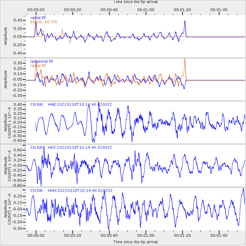
Signal To Noise
| Channel | StoN | STA | LTA |
| CN:INK: :HHZ:20220318T19:14:46.62003Z | 2.3850749 | 3.6460455E-7 | 1.5286922E-7 |
| CN:INK: :HHN:20220318T19:14:46.62003Z | 0.57286173 | 8.730311E-8 | 1.5239823E-7 |
| CN:INK: :HHE:20220318T19:14:46.62003Z | 2.3102708 | 2.8635773E-7 | 1.2394986E-7 |
| Arrivals |
| Ps | |
| PpPs | |
| PsPs/PpSs | |


