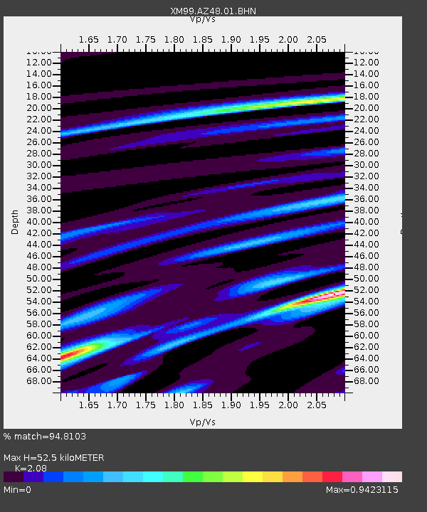
AZ48 Arizona48 - Earthquake Result Viewer

Earthquake location: El Salvador
Earthquake latitude/longitude: 13.0/-88.7
Earthquake time(UTC): 2001/01/13 (013) 17:33:32 GMT
Earthquake Depth: 60 km
Earthquake Magnitude: 6.4 MB, 7.8 MS, 7.7 MW, 7.5 ME
Earthquake Catalog/Contributor: WHDF/NEIC
Network: XM Rio Grande Seismic Transect
Station: AZ48 Arizona48
Lat/Lon: 36.76 N/109.54 W
Elevation: 1664 m
Distance: 30.1 deg
Az: 325.237 deg
Baz: 136.218 deg
Ray Param: 0.07932926
Estimated Moho Depth: 52.5 km
Estimated Crust Vp/Vs: 2.08
Assumed Crust Vp: 6.476 km/s
Estimated Crust Vs: 3.113 km/s
Estimated Crust Poisson's Ratio: 0.35
Radial Match: 94.8103 %
Radial Bump: 322
Transverse Match: 78.91446 %
Transverse Bump: 400
SOD ConfigId: 16820
Insert Time: 2010-02-26 17:18:52.027 +0000
GWidth: 2.5
Max Bumps: 400
Tol: 0.001

Signal To Noise

ChannelStoNSTALTA
XM:AZ48:01:BHN:20010113T17:39:06.325007Z1.6816599.207449E-75.475218E-7
XM:AZ48:01:BHE:20010113T17:39:06.325007Z3.11150841.2682169E-64.0758908E-7
XM:AZ48:01:BHZ:20010113T17:39:06.325007Z8.4954352.6208183E-63.0849728E-7
Arrivals
Ps9.4 SECOND
PpPs23 SECOND
PsPs/PpSs33 SECOND