You are here: Home > Network List > US - United States National Seismic Network Stations List
> Station MSO Missoula, Montana, USA > Earthquake Result Viewer
MSO Missoula, Montana, USA - Earthquake Result Viewer
*The percent match for this event was below the threshold and hence no stack was calculated.
| Earthquake location: |
Northeast Of Taiwan |
| Earthquake latitude/longitude: |
25.7/124.0 |
| Earthquake time(UTC): |
2022/03/18 (077) 19:04:18 GMT |
| Earthquake Depth: |
167 km |
| Earthquake Magnitude: |
5.9 mww |
| Earthquake Catalog/Contributor: |
NEIC PDE/us |
|
| Network: |
US United States National Seismic Network |
| Station: |
MSO Missoula, Montana, USA |
| Lat/Lon: |
46.83 N/113.94 W |
| Elevation: |
1264 m |
|
| Distance: |
90.9 deg |
| Az: |
35.589 deg |
| Baz: |
310.106 deg |
| Ray Param: |
$rayparam |
*The percent match for this event was below the threshold and hence was not used in the summary stack. |
|
| Radial Match: |
59.741535 % |
| Radial Bump: |
400 |
| Transverse Match: |
52.0705 % |
| Transverse Bump: |
337 |
| SOD ConfigId: |
27527651 |
| Insert Time: |
2022-04-01 19:22:43.068 +0000 |
| GWidth: |
2.5 |
| Max Bumps: |
400 |
| Tol: |
0.001 |
|
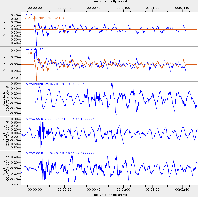
Signal To Noise
| Channel | StoN | STA | LTA |
| US:MSO:00:BHZ:20220318T19:16:32.149999Z | 3.3544812 | 3.9228797E-7 | 1.16944456E-7 |
| US:MSO:00:BH1:20220318T19:16:32.149999Z | 1.2743051 | 1.4445038E-7 | 1.1335621E-7 |
| US:MSO:00:BH2:20220318T19:16:32.149999Z | 0.56407577 | 1.3141558E-7 | 2.3297503E-7 |
| Arrivals |
| Ps | |
| PpPs | |
| PsPs/PpSs | |


