You are here: Home > Network List > XM99 - Rio Grande Seismic Transect Stations List
> Station AZ48 Arizona48 > Earthquake Result Viewer
AZ48 Arizona48 - Earthquake Result Viewer
| Earthquake location: |
Fiji Islands Region |
| Earthquake latitude/longitude: |
-18.1/-176.9 |
| Earthquake time(UTC): |
2001/04/28 (118) 04:49:53 GMT |
| Earthquake Depth: |
352 km |
| Earthquake Magnitude: |
6.2 MB, 6.8 MW, 6.8 MW |
| Earthquake Catalog/Contributor: |
WHDF/NEIC |
|
| Network: |
XM Rio Grande Seismic Transect |
| Station: |
AZ48 Arizona48 |
| Lat/Lon: |
36.76 N/109.54 W |
| Elevation: |
1664 m |
|
| Distance: |
83.7 deg |
| Az: |
48.237 deg |
| Baz: |
242.081 deg |
| Ray Param: |
0.04508829 |
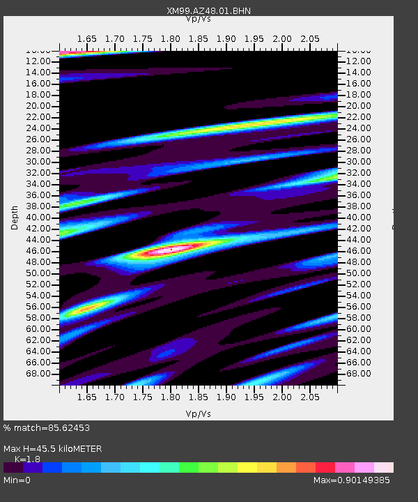
| Estimated Moho Depth: |
45.5 km |
| Estimated Crust Vp/Vs: |
1.80 |
| Assumed Crust Vp: |
6.476 km/s |
| Estimated Crust Vs: |
3.598 km/s |
| Estimated Crust Poisson's Ratio: |
0.28 |
|
| Radial Match: |
85.62453 % |
| Radial Bump: |
400 |
| Transverse Match: |
87.2608 % |
| Transverse Bump: |
400 |
| SOD ConfigId: |
4714 |
| Insert Time: |
2010-02-26 17:18:54.601 +0000 |
| GWidth: |
2.5 |
| Max Bumps: |
400 |
| Tol: |
0.001 |
|
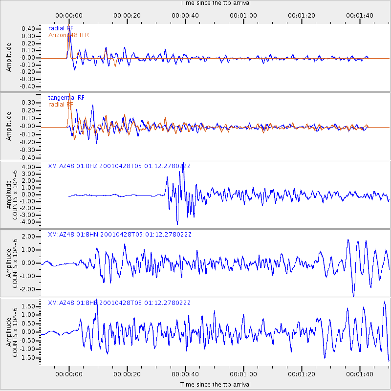
Signal To Noise
| Channel | StoN | STA | LTA |
| XM:AZ48:01:BHN:20010428T05:01:12.278022Z | 0.95848095 | 9.946344E-8 | 1.0377195E-7 |
| XM:AZ48:01:BHE:20010428T05:01:12.278022Z | 3.1919045 | 2.6942942E-7 | 8.441024E-8 |
| XM:AZ48:01:BHZ:20010428T05:01:12.278022Z | 12.819086 | 9.37331E-7 | 7.311995E-8 |
| Arrivals |
| Ps | 5.8 SECOND |
| PpPs | 19 SECOND |
| PsPs/PpSs | 25 SECOND |


