You are here: Home > Network List > IU - Global Seismograph Network (GSN - IRIS/USGS) Stations List
> Station POHA Pohakuloa, Hawaii, USA > Earthquake Result Viewer
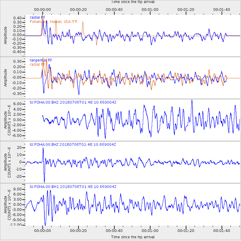
POHA Pohakuloa, Hawaii, USA - Earthquake Result Viewer
*The percent match for this event was below the threshold and hence no stack was calculated.
| Earthquake location: |
Near East Coast Of Kamchatka |
| Earthquake latitude/longitude: |
51.6/157.9 |
| Earthquake time(UTC): |
2018/07/06 (187) 01:40:08 GMT |
| Earthquake Depth: |
80 km |
| Earthquake Magnitude: |
6.1 Mwp |
| Earthquake Catalog/Contributor: |
NEIC PDE/us |
|
| Network: |
IU Global Seismograph Network (GSN - IRIS/USGS) |
| Station: |
POHA Pohakuloa, Hawaii, USA |
| Lat/Lon: |
19.76 N/155.53 W |
| Elevation: |
1990 m |
|
| Distance: |
48.2 deg |
| Az: |
113.405 deg |
| Baz: |
322.587 deg |
| Ray Param: |
$rayparam |
*The percent match for this event was below the threshold and hence was not used in the summary stack. |
|
| Radial Match: |
54.297302 % |
| Radial Bump: |
400 |
| Transverse Match: |
68.215675 % |
| Transverse Bump: |
400 |
| SOD ConfigId: |
2752131 |
| Insert Time: |
2018-07-20 01:50:23.056 +0000 |
| GWidth: |
2.5 |
| Max Bumps: |
400 |
| Tol: |
0.001 |
|
Signal To Noise
| Channel | StoN | STA | LTA |
| IU:POHA:00:BHZ:20180706T01:48:10.669004Z | 7.4496017 | 9.380503E-6 | 1.2591953E-6 |
| IU:POHA:00:BH1:20180706T01:48:10.669004Z | 4.0613775 | 6.2590543E-6 | 1.541116E-6 |
| IU:POHA:00:BH2:20180706T01:48:10.669004Z | 2.2709062 | 2.8328952E-6 | 1.2474734E-6 |
| Arrivals |
| Ps | |
| PpPs | |
| PsPs/PpSs | |


