You are here: Home > Network List > IU - Global Seismograph Network (GSN - IRIS/USGS) Stations List
> Station RSSD Black Hills, South Dakota, USA > Earthquake Result Viewer
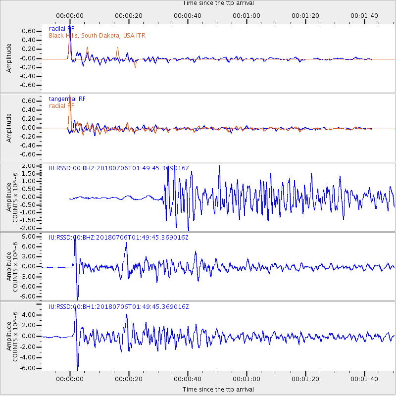
RSSD Black Hills, South Dakota, USA - Earthquake Result Viewer
| Earthquake location: |
Near East Coast Of Kamchatka |
| Earthquake latitude/longitude: |
51.6/157.9 |
| Earthquake time(UTC): |
2018/07/06 (187) 01:40:08 GMT |
| Earthquake Depth: |
80 km |
| Earthquake Magnitude: |
6.1 Mwp |
| Earthquake Catalog/Contributor: |
NEIC PDE/us |
|
| Network: |
IU Global Seismograph Network (GSN - IRIS/USGS) |
| Station: |
RSSD Black Hills, South Dakota, USA |
| Lat/Lon: |
44.12 N/104.04 W |
| Elevation: |
2090 m |
|
| Distance: |
61.4 deg |
| Az: |
54.317 deg |
| Baz: |
315.313 deg |
| Ray Param: |
0.060706794 |
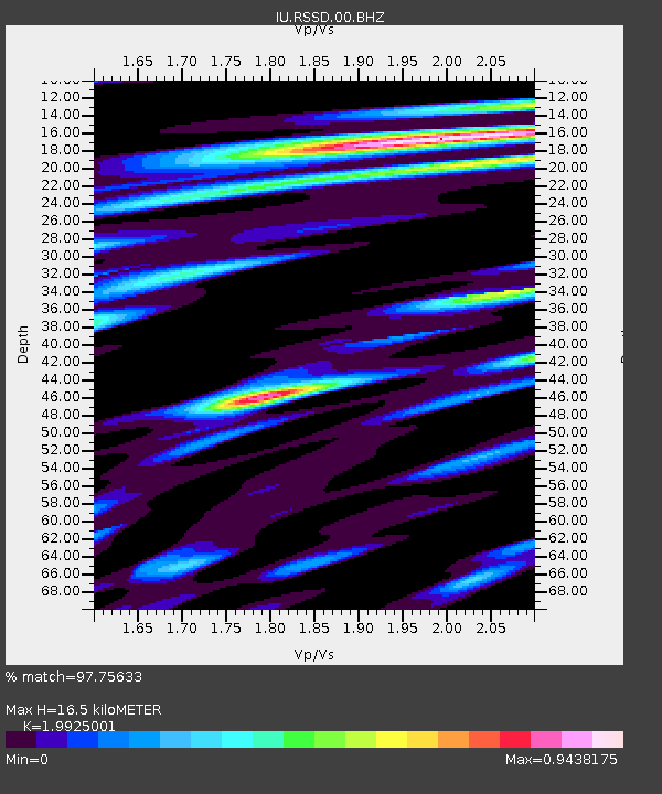
| Estimated Moho Depth: |
16.5 km |
| Estimated Crust Vp/Vs: |
1.99 |
| Assumed Crust Vp: |
6.242 km/s |
| Estimated Crust Vs: |
3.133 km/s |
| Estimated Crust Poisson's Ratio: |
0.33 |
|
| Radial Match: |
97.75633 % |
| Radial Bump: |
381 |
| Transverse Match: |
95.18356 % |
| Transverse Bump: |
400 |
| SOD ConfigId: |
2752131 |
| Insert Time: |
2018-07-20 01:50:26.205 +0000 |
| GWidth: |
2.5 |
| Max Bumps: |
400 |
| Tol: |
0.001 |
|
Signal To Noise
| Channel | StoN | STA | LTA |
| IU:RSSD:00:BHZ:20180706T01:49:45.369016Z | 62.38741 | 4.002347E-6 | 6.415313E-8 |
| IU:RSSD:00:BH1:20180706T01:49:45.369016Z | 39.817623 | 2.4042606E-6 | 6.038182E-8 |
| IU:RSSD:00:BH2:20180706T01:49:45.369016Z | 12.516739 | 7.1714845E-7 | 5.7295154E-8 |
| Arrivals |
| Ps | 2.7 SECOND |
| PpPs | 7.6 SECOND |
| PsPs/PpSs | 10 SECOND |


