You are here: Home > Network List > IW - Intermountain West Stations List
> Station IMW Indian Meadow, Wyoming, USA > Earthquake Result Viewer
IMW Indian Meadow, Wyoming, USA - Earthquake Result Viewer

| Earthquake location: |
Near East Coast Of Kamchatka |
| Earthquake latitude/longitude: |
51.6/157.9 |
| Earthquake time(UTC): |
2018/07/06 (187) 01:40:08 GMT |
| Earthquake Depth: |
80 km |
| Earthquake Magnitude: |
6.1 Mwp |
| Earthquake Catalog/Contributor: |
NEIC PDE/us |
|
| Network: |
IW Intermountain West |
| Station: |
IMW Indian Meadow, Wyoming, USA |
| Lat/Lon: |
43.90 N/110.94 W |
| Elevation: |
2646 m |
|
| Distance: |
57.9 deg |
| Az: |
58.51 deg |
| Baz: |
312.65 deg |
| Ray Param: |
0.06294327 |
| Estimated Moho Depth: |
69.5 km |
| Estimated Crust Vp/Vs: |
1.80 |
| Assumed Crust Vp: |
6.207 km/s |
| Estimated Crust Vs: |
3.453 km/s |
| Estimated Crust Poisson's Ratio: |
0.28 |
|
| Radial Match: |
95.868515 % |
| Radial Bump: |
400 |
| Transverse Match: |
86.991936 % |
| Transverse Bump: |
400 |
| SOD ConfigId: |
2752131 |
| Insert Time: |
2018-07-20 01:50:51.781 +0000 |
| GWidth: |
2.5 |
| Max Bumps: |
400 |
| Tol: |
0.001 |
|
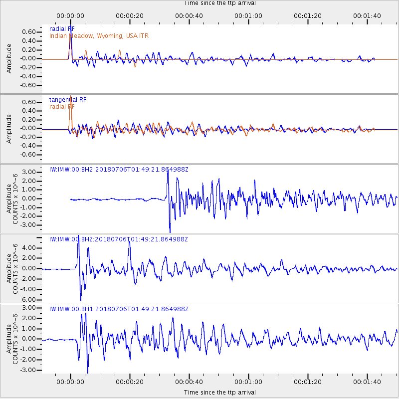
Signal To Noise
| Channel | StoN | STA | LTA |
| IW:IMW:00:BHZ:20180706T01:49:21.864988Z | 35.60774 | 2.5695404E-6 | 7.216241E-8 |
| IW:IMW:00:BH1:20180706T01:49:21.864988Z | 16.489658 | 9.2302065E-7 | 5.5975725E-8 |
| IW:IMW:00:BH2:20180706T01:49:21.864988Z | 27.649492 | 1.3173516E-6 | 4.7644694E-8 |
| Arrivals |
| Ps | 9.3 SECOND |
| PpPs | 30 SECOND |
| PsPs/PpSs | 39 SECOND |


