You are here: Home > Network List > XM99 - Rio Grande Seismic Transect Stations List
> Station AZ48 Arizona48 > Earthquake Result Viewer
AZ48 Arizona48 - Earthquake Result Viewer

| Earthquake location: |
Northern Chile |
| Earthquake latitude/longitude: |
-18.9/-69.2 |
| Earthquake time(UTC): |
1999/11/30 (334) 04:01:53 GMT |
| Earthquake Depth: |
128 km |
| Earthquake Magnitude: |
6.2 MB, 6.6 MW, 6.5 MW |
| Earthquake Catalog/Contributor: |
WHDF/NEIC |
|
| Network: |
XM Rio Grande Seismic Transect |
| Station: |
AZ48 Arizona48 |
| Lat/Lon: |
36.76 N/109.54 W |
| Elevation: |
1664 m |
|
| Distance: |
67.2 deg |
| Az: |
325.653 deg |
| Baz: |
138.307 deg |
| Ray Param: |
0.056762338 |
| Estimated Moho Depth: |
66.75 km |
| Estimated Crust Vp/Vs: |
1.85 |
| Assumed Crust Vp: |
6.476 km/s |
| Estimated Crust Vs: |
3.496 km/s |
| Estimated Crust Poisson's Ratio: |
0.29 |
|
| Radial Match: |
90.77823 % |
| Radial Bump: |
400 |
| Transverse Match: |
64.28154 % |
| Transverse Bump: |
400 |
| SOD ConfigId: |
27569 |
| Insert Time: |
2010-02-26 17:18:58.255 +0000 |
| GWidth: |
2.5 |
| Max Bumps: |
400 |
| Tol: |
0.001 |
|
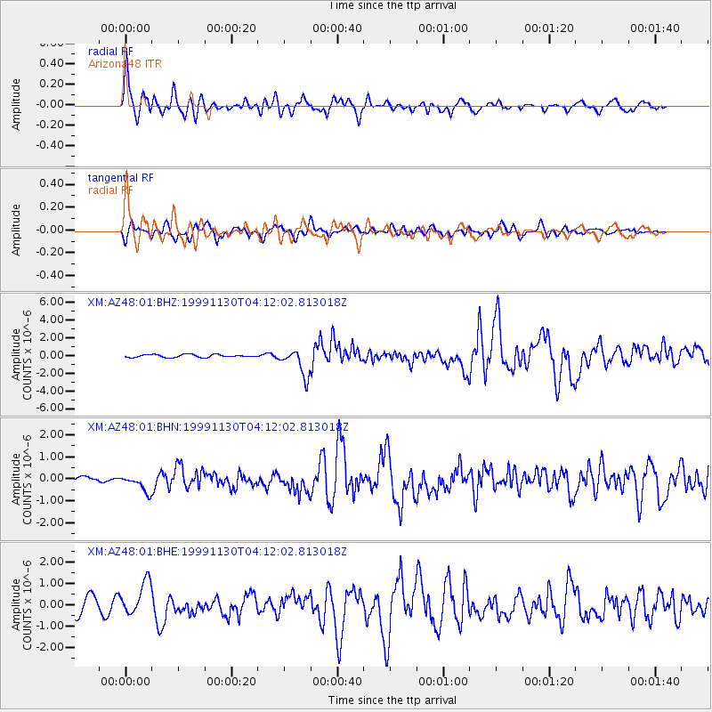
Signal To Noise
| Channel | StoN | STA | LTA |
| XM:AZ48:01:BHN:19991130T04:12:02.813018Z | 1.1580528 | 3.8335153E-7 | 3.3103115E-7 |
| XM:AZ48:01:BHE:19991130T04:12:02.813018Z | 2.4532962 | 7.965649E-7 | 3.2469168E-7 |
| XM:AZ48:01:BHZ:19991130T04:12:02.813018Z | 9.673631 | 1.5396395E-6 | 1.5915839E-7 |
| Arrivals |
| Ps | 9.1 SECOND |
| PpPs | 28 SECOND |
| PsPs/PpSs | 37 SECOND |


