You are here: Home > Network List > US - United States National Seismic Network Stations List
> Station WMOK Wichita Mountains, Oklahoma, USA > Earthquake Result Viewer
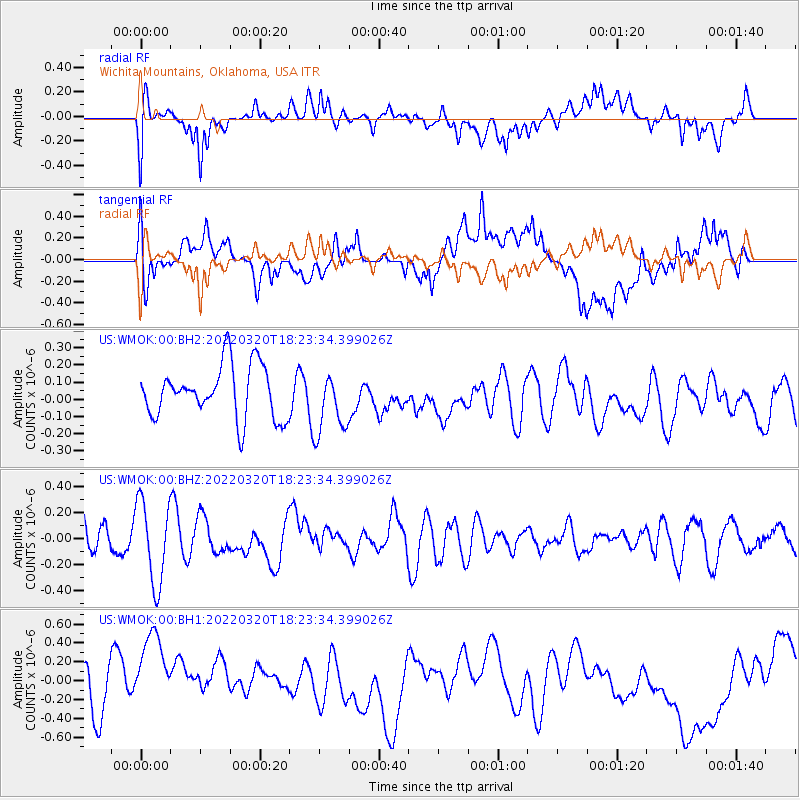
WMOK Wichita Mountains, Oklahoma, USA - Earthquake Result Viewer
*The percent match for this event was below the threshold and hence no stack was calculated.
| Earthquake location: |
Kermadec Islands Region |
| Earthquake latitude/longitude: |
-28.9/-176.8 |
| Earthquake time(UTC): |
2022/03/20 (079) 18:10:34 GMT |
| Earthquake Depth: |
10 km |
| Earthquake Magnitude: |
5.8 mww |
| Earthquake Catalog/Contributor: |
NEIC PDE/us |
|
| Network: |
US United States National Seismic Network |
| Station: |
WMOK Wichita Mountains, Oklahoma, USA |
| Lat/Lon: |
34.74 N/98.78 W |
| Elevation: |
486 m |
|
| Distance: |
97.0 deg |
| Az: |
54.257 deg |
| Baz: |
239.776 deg |
| Ray Param: |
$rayparam |
*The percent match for this event was below the threshold and hence was not used in the summary stack. |
|
| Radial Match: |
63.403835 % |
| Radial Bump: |
400 |
| Transverse Match: |
44.157314 % |
| Transverse Bump: |
400 |
| SOD ConfigId: |
27527651 |
| Insert Time: |
2022-04-03 18:26:58.492 +0000 |
| GWidth: |
2.5 |
| Max Bumps: |
400 |
| Tol: |
0.001 |
|
Signal To Noise
| Channel | StoN | STA | LTA |
| US:WMOK:00:BHZ:20220320T18:23:34.399026Z | 1.7645369 | 3.1764574E-7 | 1.800165E-7 |
| US:WMOK:00:BH1:20220320T18:23:34.399026Z | 3.1570747 | 5.769992E-7 | 1.8276386E-7 |
| US:WMOK:00:BH2:20220320T18:23:34.399026Z | 1.2122599 | 1.8361062E-7 | 1.5146145E-7 |
| Arrivals |
| Ps | |
| PpPs | |
| PsPs/PpSs | |


