You are here: Home > Network List > XM99 - Rio Grande Seismic Transect Stations List
> Station AZ48 Arizona48 > Earthquake Result Viewer
AZ48 Arizona48 - Earthquake Result Viewer
| Earthquake location: |
Komandorskiye Ostrova Region |
| Earthquake latitude/longitude: |
55.1/165.4 |
| Earthquake time(UTC): |
1999/11/26 (330) 00:29:00 GMT |
| Earthquake Depth: |
33 km |
| Earthquake Magnitude: |
5.6 MB, 5.8 MS |
| Earthquake Catalog/Contributor: |
WHDF/NEIC |
|
| Network: |
XM Rio Grande Seismic Transect |
| Station: |
AZ48 Arizona48 |
| Lat/Lon: |
36.76 N/109.54 W |
| Elevation: |
1664 m |
|
| Distance: |
58.2 deg |
| Az: |
70.331 deg |
| Baz: |
317.673 deg |
| Ray Param: |
0.06295536 |
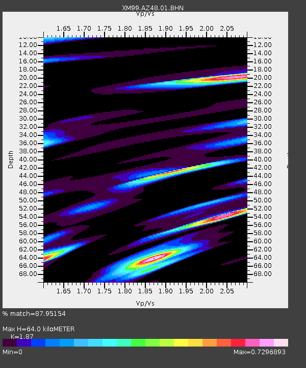
| Estimated Moho Depth: |
64.0 km |
| Estimated Crust Vp/Vs: |
1.87 |
| Assumed Crust Vp: |
6.476 km/s |
| Estimated Crust Vs: |
3.463 km/s |
| Estimated Crust Poisson's Ratio: |
0.30 |
|
| Radial Match: |
87.95154 % |
| Radial Bump: |
400 |
| Transverse Match: |
67.860916 % |
| Transverse Bump: |
400 |
| SOD ConfigId: |
27569 |
| Insert Time: |
2010-02-26 17:18:59.822 +0000 |
| GWidth: |
2.5 |
| Max Bumps: |
400 |
| Tol: |
0.001 |
|

Signal To Noise
| Channel | StoN | STA | LTA |
| XM:AZ48:01:BHN:19991126T00:38:20.262004Z | 3.1947348 | 2.9535224E-7 | 9.244969E-8 |
| XM:AZ48:01:BHE:19991126T00:38:20.262004Z | 1.2712749 | 2.9063816E-7 | 2.2861941E-7 |
| XM:AZ48:01:BHZ:19991126T00:38:20.262004Z | 2.1776595 | 3.476703E-7 | 1.5965318E-7 |
| Arrivals |
| Ps | 9.0 SECOND |
| PpPs | 27 SECOND |
| PsPs/PpSs | 36 SECOND |


