You are here: Home > Network List > CM - Red Sismologica Nacional de Columbia Stations List
> Station SMAR Santa Marta, Magdalena, Colombia > Earthquake Result Viewer
SMAR Santa Marta, Magdalena, Colombia - Earthquake Result Viewer
| Earthquake location: |
Northern Mid-Atlantic Ridge |
| Earthquake latitude/longitude: |
10.7/-43.4 |
| Earthquake time(UTC): |
2022/03/22 (081) 16:35:08 GMT |
| Earthquake Depth: |
10 km |
| Earthquake Magnitude: |
6.7 mww |
| Earthquake Catalog/Contributor: |
NEIC PDE/us |
|
| Network: |
CM Red Sismologica Nacional de Columbia |
| Station: |
SMAR Santa Marta, Magdalena, Colombia |
| Lat/Lon: |
11.16 N/74.22 W |
| Elevation: |
122 m |
|
| Distance: |
30.3 deg |
| Az: |
273.75 deg |
| Baz: |
87.788 deg |
| Ray Param: |
0.079468004 |
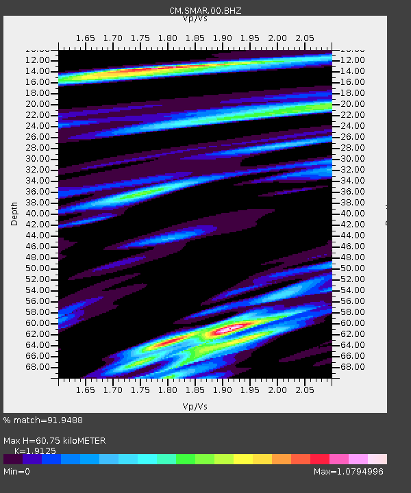
| Estimated Moho Depth: |
60.75 km |
| Estimated Crust Vp/Vs: |
1.91 |
| Assumed Crust Vp: |
5.129 km/s |
| Estimated Crust Vs: |
2.682 km/s |
| Estimated Crust Poisson's Ratio: |
0.31 |
|
| Radial Match: |
91.9488 % |
| Radial Bump: |
374 |
| Transverse Match: |
70.77171 % |
| Transverse Bump: |
400 |
| SOD ConfigId: |
27527651 |
| Insert Time: |
2022-04-05 16:47:08.250 +0000 |
| GWidth: |
2.5 |
| Max Bumps: |
400 |
| Tol: |
0.001 |
|

Signal To Noise
| Channel | StoN | STA | LTA |
| CM:SMAR:00:BHZ:20220322T16:40:48.519Z | 7.8443804 | 1.7012517E-6 | 2.1687521E-7 |
| CM:SMAR:00:BHN:20220322T16:40:48.519Z | 1.864917 | 3.6867027E-7 | 1.9768723E-7 |
| CM:SMAR:00:BHE:20220322T16:40:48.519Z | 7.6056685 | 1.3569542E-6 | 1.7841352E-7 |
| Arrivals |
| Ps | 11 SECOND |
| PpPs | 33 SECOND |
| PsPs/PpSs | 44 SECOND |


