You are here: Home > Network List > NM - Cooperative New Madrid Seismic Network Stations List
> Station CLTN Cedars of Lebanon,TN > Earthquake Result Viewer
CLTN Cedars of Lebanon,TN - Earthquake Result Viewer
| Earthquake location: |
Near East Coast Of Kamchatka |
| Earthquake latitude/longitude: |
51.6/157.9 |
| Earthquake time(UTC): |
2018/07/06 (187) 01:40:08 GMT |
| Earthquake Depth: |
80 km |
| Earthquake Magnitude: |
6.1 Mwp |
| Earthquake Catalog/Contributor: |
NEIC PDE/us |
|
| Network: |
NM Cooperative New Madrid Seismic Network |
| Station: |
CLTN Cedars of Lebanon,TN |
| Lat/Lon: |
36.09 N/86.33 W |
| Elevation: |
208 m |
|
| Distance: |
76.2 deg |
| Az: |
48.661 deg |
| Baz: |
324.69 deg |
| Ray Param: |
0.050981432 |
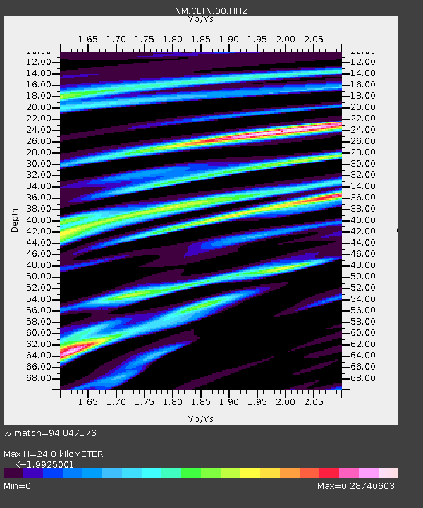
| Estimated Moho Depth: |
24.0 km |
| Estimated Crust Vp/Vs: |
1.99 |
| Assumed Crust Vp: |
6.444 km/s |
| Estimated Crust Vs: |
3.234 km/s |
| Estimated Crust Poisson's Ratio: |
0.33 |
|
| Radial Match: |
94.847176 % |
| Radial Bump: |
292 |
| Transverse Match: |
89.39464 % |
| Transverse Bump: |
400 |
| SOD ConfigId: |
2752131 |
| Insert Time: |
2018-07-20 01:52:12.324 +0000 |
| GWidth: |
2.5 |
| Max Bumps: |
400 |
| Tol: |
0.001 |
|

Signal To Noise
| Channel | StoN | STA | LTA |
| NM:CLTN:00:HHZ:20180706T01:51:17.08502Z | 28.677954 | 1.0711542E-6 | 3.7351136E-8 |
| NM:CLTN:00:HHN:20180706T01:51:17.08502Z | 16.330484 | 3.82821E-7 | 2.344211E-8 |
| NM:CLTN:00:HHE:20180706T01:51:17.08502Z | 7.680793 | 1.486757E-7 | 1.9356817E-8 |
| Arrivals |
| Ps | 3.8 SECOND |
| PpPs | 11 SECOND |
| PsPs/PpSs | 15 SECOND |


