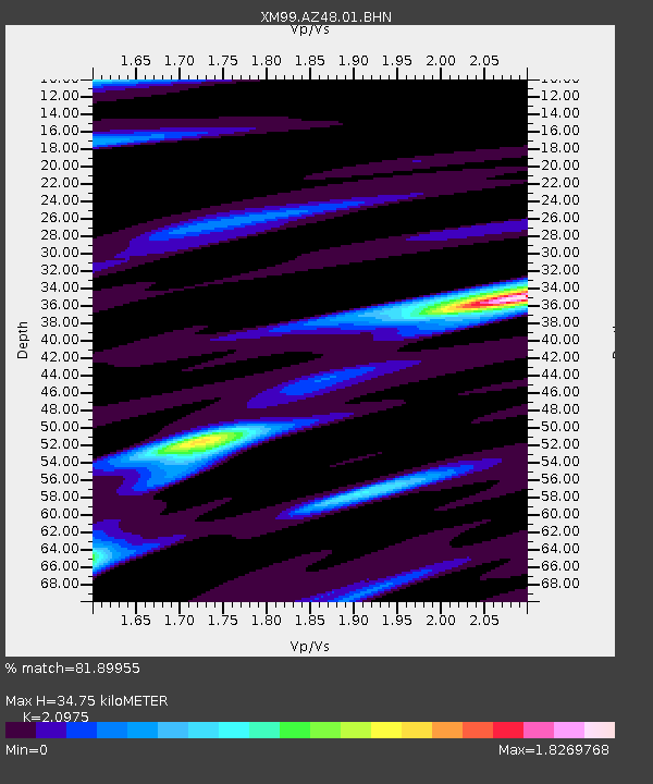
AZ48 Arizona48 - Earthquake Result Viewer

Earthquake location: Kodiak Island Region, Alaska
Earthquake latitude/longitude: 57.4/-154.5
Earthquake time(UTC): 1999/12/07 (341) 00:19:49 GMT
Earthquake Depth: 41 km
Earthquake Magnitude: 6.5 MB, 6.1 MS, 6.4 MW, 6.3 ML
Earthquake Catalog/Contributor: WHDF/NEIC
Network: XM Rio Grande Seismic Transect
Station: AZ48 Arizona48
Lat/Lon: 36.76 N/109.54 W
Elevation: 1664 m
Distance: 36.0 deg
Az: 105.231 deg
Baz: 319.376 deg
Ray Param: 0.076810405
Estimated Moho Depth: 34.75 km
Estimated Crust Vp/Vs: 2.10
Assumed Crust Vp: 6.476 km/s
Estimated Crust Vs: 3.087 km/s
Estimated Crust Poisson's Ratio: 0.35
Radial Match: 81.89955 %
Radial Bump: 400
Transverse Match: 75.63265 %
Transverse Bump: 400
SOD ConfigId: 27569
Insert Time: 2010-02-26 17:19:06.857 +0000
GWidth: 2.5
Max Bumps: 400
Tol: 0.001

Signal To Noise

ChannelStoNSTALTA
XM:AZ48:01:BHN:19991207T00:26:16.663009Z2.39916871.4308936E-65.9641224E-7
XM:AZ48:01:BHE:19991207T00:26:16.663009Z2.52566031.6556502E-66.555316E-7
XM:AZ48:01:BHZ:19991207T00:26:16.663009Z5.470343.114171E-65.692829E-7
Arrivals
Ps6.3 SECOND
PpPs16 SECOND
PsPs/PpSs22 SECOND