You are here: Home > Network List > CN - Canadian National Seismograph Network Stations List
> Station POIN Pond Inlet, NU, CA > Earthquake Result Viewer
POIN Pond Inlet, NU, CA - Earthquake Result Viewer
| Earthquake location: |
Northern Mid-Atlantic Ridge |
| Earthquake latitude/longitude: |
10.7/-43.4 |
| Earthquake time(UTC): |
2022/03/22 (081) 16:35:08 GMT |
| Earthquake Depth: |
10 km |
| Earthquake Magnitude: |
6.7 mww |
| Earthquake Catalog/Contributor: |
NEIC PDE/us |
|
| Network: |
CN Canadian National Seismograph Network |
| Station: |
POIN Pond Inlet, NU, CA |
| Lat/Lon: |
72.70 N/77.96 W |
| Elevation: |
21 m |
|
| Distance: |
65.2 deg |
| Az: |
349.223 deg |
| Baz: |
142.107 deg |
| Ray Param: |
0.0584052 |
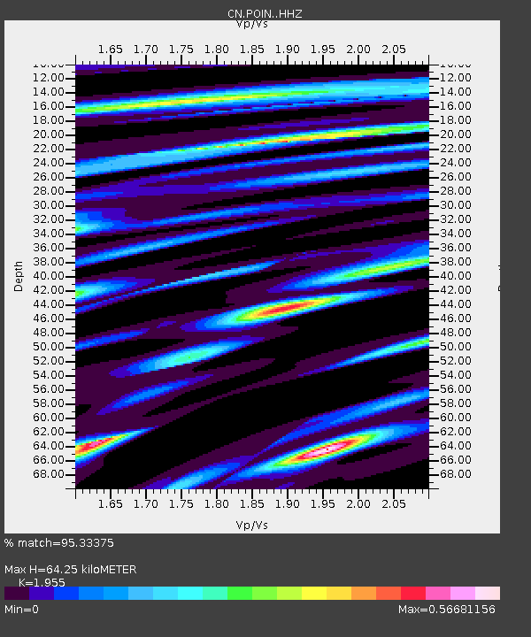
| Estimated Moho Depth: |
64.25 km |
| Estimated Crust Vp/Vs: |
1.96 |
| Assumed Crust Vp: |
6.367 km/s |
| Estimated Crust Vs: |
3.257 km/s |
| Estimated Crust Poisson's Ratio: |
0.32 |
|
| Radial Match: |
95.33375 % |
| Radial Bump: |
233 |
| Transverse Match: |
68.00755 % |
| Transverse Bump: |
400 |
| SOD ConfigId: |
27527651 |
| Insert Time: |
2022-04-05 16:48:37.017 +0000 |
| GWidth: |
2.5 |
| Max Bumps: |
400 |
| Tol: |
0.001 |
|

Signal To Noise
| Channel | StoN | STA | LTA |
| CN:POIN: :HHZ:20220322T16:45:18.479999Z | 3.6960225 | 3.691618E-7 | 9.988083E-8 |
| CN:POIN: :HHN:20220322T16:45:18.479999Z | 0.76341885 | 8.582224E-8 | 1.1241829E-7 |
| CN:POIN: :HHE:20220322T16:45:18.479999Z | 1.6798176 | 2.1619913E-7 | 1.2870393E-7 |
| Arrivals |
| Ps | 10 SECOND |
| PpPs | 29 SECOND |
| PsPs/PpSs | 39 SECOND |


