You are here: Home > Network List > G - GEOSCOPE Stations List
> Station TAM Tamanrasset, Algeria > Earthquake Result Viewer
TAM Tamanrasset, Algeria - Earthquake Result Viewer
| Earthquake location: |
Northern Mid-Atlantic Ridge |
| Earthquake latitude/longitude: |
10.7/-43.4 |
| Earthquake time(UTC): |
2022/03/22 (081) 16:35:08 GMT |
| Earthquake Depth: |
10 km |
| Earthquake Magnitude: |
6.7 mww |
| Earthquake Catalog/Contributor: |
NEIC PDE/us |
|
| Network: |
G GEOSCOPE |
| Station: |
TAM Tamanrasset, Algeria |
| Lat/Lon: |
22.79 N/5.53 E |
| Elevation: |
1377 m |
|
| Distance: |
48.1 deg |
| Az: |
69.06 deg |
| Baz: |
264.001 deg |
| Ray Param: |
0.069564946 |
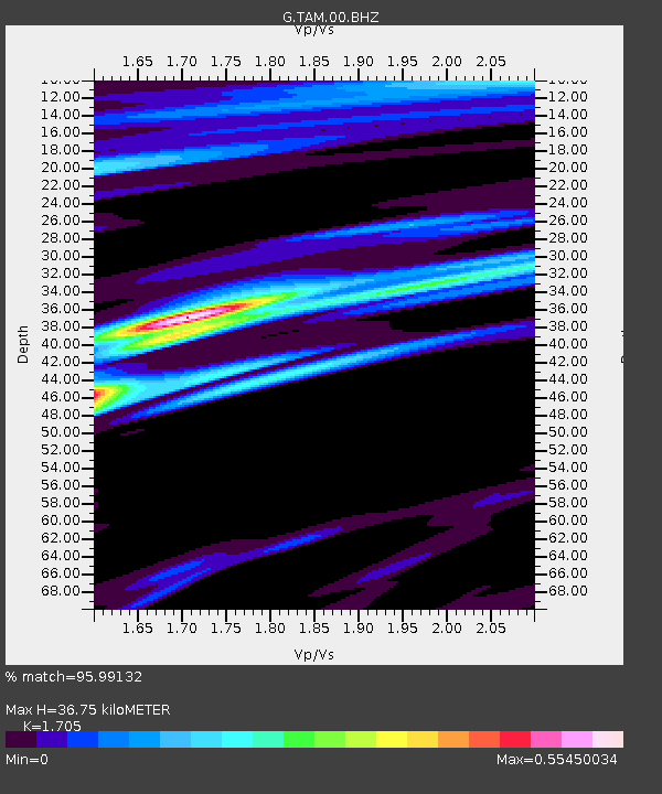
| Estimated Moho Depth: |
36.75 km |
| Estimated Crust Vp/Vs: |
1.71 |
| Assumed Crust Vp: |
6.61 km/s |
| Estimated Crust Vs: |
3.877 km/s |
| Estimated Crust Poisson's Ratio: |
0.24 |
|
| Radial Match: |
95.99132 % |
| Radial Bump: |
252 |
| Transverse Match: |
81.2449 % |
| Transverse Bump: |
400 |
| SOD ConfigId: |
27527651 |
| Insert Time: |
2022-04-05 16:50:38.300 +0000 |
| GWidth: |
2.5 |
| Max Bumps: |
400 |
| Tol: |
0.001 |
|
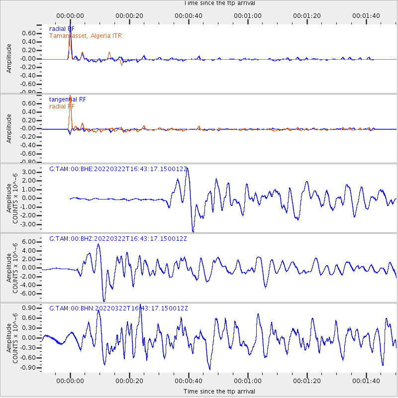
Signal To Noise
| Channel | StoN | STA | LTA |
| G:TAM:00:BHZ:20220322T16:43:17.150012Z | 7.282561 | 8.1117895E-7 | 1.11386505E-7 |
| G:TAM:00:BHN:20220322T16:43:17.150012Z | 1.7820295 | 1.5913179E-7 | 8.929806E-8 |
| G:TAM:00:BHE:20220322T16:43:17.150012Z | 6.2057123 | 4.2761653E-7 | 6.890692E-8 |
| Arrivals |
| Ps | 4.2 SECOND |
| PpPs | 14 SECOND |
| PsPs/PpSs | 18 SECOND |


