You are here: Home > Network List > XM99 - Rio Grande Seismic Transect Stations List
> Station AZ48 Arizona48 > Earthquake Result Viewer
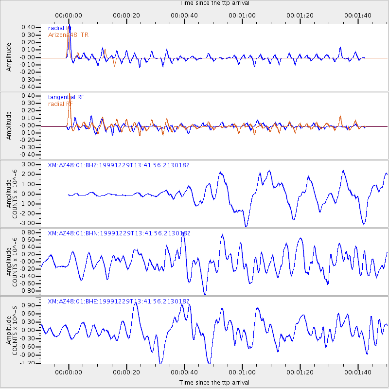
AZ48 Arizona48 - Earthquake Result Viewer

| Earthquake location: |
Santa Cruz Islands |
| Earthquake latitude/longitude: |
-10.9/165.4 |
| Earthquake time(UTC): |
1999/12/29 (363) 13:29:19 GMT |
| Earthquake Depth: |
33 km |
| Earthquake Magnitude: |
5.6 MB, 6.8 MS, 6.8 MW, 6.3 MW |
| Earthquake Catalog/Contributor: |
WHDF/NEIC |
|
| Network: |
XM Rio Grande Seismic Transect |
| Station: |
AZ48 Arizona48 |
| Lat/Lon: |
36.76 N/109.54 W |
| Elevation: |
1664 m |
|
| Distance: |
92.5 deg |
| Az: |
53.218 deg |
| Baz: |
258.436 deg |
| Ray Param: |
0.041428056 |
| Estimated Moho Depth: |
50.5 km |
| Estimated Crust Vp/Vs: |
1.61 |
| Assumed Crust Vp: |
6.476 km/s |
| Estimated Crust Vs: |
4.035 km/s |
| Estimated Crust Poisson's Ratio: |
0.18 |
|
| Radial Match: |
91.48664 % |
| Radial Bump: |
400 |
| Transverse Match: |
65.24858 % |
| Transverse Bump: |
400 |
| SOD ConfigId: |
27569 |
| Insert Time: |
2010-02-26 17:19:08.566 +0000 |
| GWidth: |
2.5 |
| Max Bumps: |
400 |
| Tol: |
0.001 |
|
Signal To Noise
| Channel | StoN | STA | LTA |
| XM:AZ48:01:BHN:19991229T13:41:56.213018Z | 2.1287 | 2.646011E-7 | 1.2430174E-7 |
| XM:AZ48:01:BHE:19991229T13:41:56.213018Z | 1.2827299 | 1.9202136E-7 | 1.4969743E-7 |
| XM:AZ48:01:BHZ:19991229T13:41:56.213018Z | 2.3853724 | 2.2840274E-7 | 9.5751396E-8 |
| Arrivals |
| Ps | 4.8 SECOND |
| PpPs | 20 SECOND |
| PsPs/PpSs | 25 SECOND |


