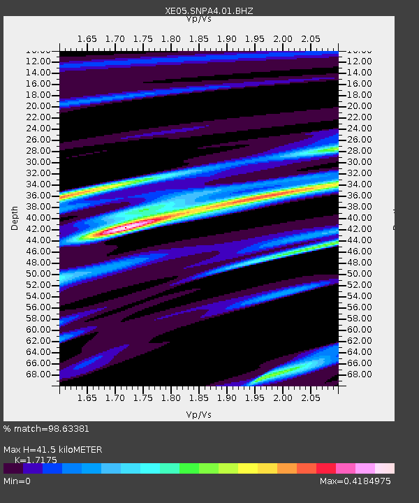
SNPA4 SNPA4 - Earthquake Result Viewer

Earthquake location: Kuril Islands
Earthquake latitude/longitude: 46.6/153.3
Earthquake time(UTC): 2006/11/15 (319) 11:14:13 GMT
Earthquake Depth: 10 km
Earthquake Magnitude: 6.5 MB, 7.8 MS, 8.3 MW, 7.9 MW
Earthquake Catalog/Contributor: WHDF/NEIC
Network: XE Sierra Nevada EarthScope Project- EarthScope Flex Array
Station: SNPA4 SNPA4
Lat/Lon: 38.50 N/120.54 W
Elevation: 1146 m
Distance: 61.0 deg
Az: 63.527 deg
Baz: 308.116 deg
Ray Param: 0.06116209
Estimated Moho Depth: 41.5 km
Estimated Crust Vp/Vs: 1.72
Assumed Crust Vp: 6.597 km/s
Estimated Crust Vs: 3.841 km/s
Estimated Crust Poisson's Ratio: 0.24
Radial Match: 98.63381 %
Radial Bump: 208
Transverse Match: 93.467445 %
Transverse Bump: 400
SOD ConfigId: 268666
Insert Time: 2010-03-09 17:48:53.600 +0000
GWidth: 2.5
Max Bumps: 400
Tol: 0.001

Signal To Noise

ChannelStoNSTALTA
XE:SNPA4:01:BHZ:20061115T11:23:55.924004Z7.98109961.5803477E-61.9801128E-7
XE:SNPA4:01:BHN:20061115T11:23:55.924004Z5.41365.4610604E-71.0087669E-7
XE:SNPA4:01:BHE:20061115T11:23:55.924004Z2.44264536.191194E-72.534627E-7
Arrivals
Ps4.7 SECOND
PpPs16 SECOND
PsPs/PpSs21 SECOND