You are here: Home > Network List > NM - Cooperative New Madrid Seismic Network Stations List
> Station X502 Temporary Arkansas > Earthquake Result Viewer
X502 Temporary Arkansas - Earthquake Result Viewer
| Earthquake location: |
Near East Coast Of Kamchatka |
| Earthquake latitude/longitude: |
51.6/157.9 |
| Earthquake time(UTC): |
2018/07/06 (187) 01:40:08 GMT |
| Earthquake Depth: |
80 km |
| Earthquake Magnitude: |
6.1 Mwp |
| Earthquake Catalog/Contributor: |
NEIC PDE/us |
|
| Network: |
NM Cooperative New Madrid Seismic Network |
| Station: |
X502 Temporary Arkansas |
| Lat/Lon: |
35.49 N/92.39 W |
| Elevation: |
344 m |
|
| Distance: |
73.7 deg |
| Az: |
53.127 deg |
| Baz: |
322.321 deg |
| Ray Param: |
0.05261475 |
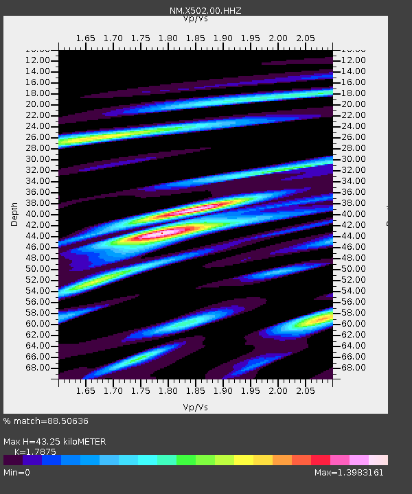
| Estimated Moho Depth: |
43.25 km |
| Estimated Crust Vp/Vs: |
1.79 |
| Assumed Crust Vp: |
6.498 km/s |
| Estimated Crust Vs: |
3.635 km/s |
| Estimated Crust Poisson's Ratio: |
0.27 |
|
| Radial Match: |
88.50636 % |
| Radial Bump: |
367 |
| Transverse Match: |
63.64957 % |
| Transverse Bump: |
347 |
| SOD ConfigId: |
2752131 |
| Insert Time: |
2018-07-20 01:52:41.261 +0000 |
| GWidth: |
2.5 |
| Max Bumps: |
400 |
| Tol: |
0.001 |
|

Signal To Noise
| Channel | StoN | STA | LTA |
| NM:X502:00:HHZ:20180706T01:51:03.030027Z | 5.4207277 | 2.9031985E-6 | 5.355735E-7 |
| NM:X502:00:HHN:20180706T01:51:03.030027Z | 3.2862802 | 1.0977263E-6 | 3.340331E-7 |
| NM:X502:00:HHE:20180706T01:51:03.030027Z | 3.4175537 | 1.0449999E-6 | 3.0577425E-7 |
| Arrivals |
| Ps | 5.4 SECOND |
| PpPs | 18 SECOND |
| PsPs/PpSs | 23 SECOND |


