You are here: Home > Network List > NO - Norwegian Seismic Array Network Stations List
> Station SPB5 > Earthquake Result Viewer
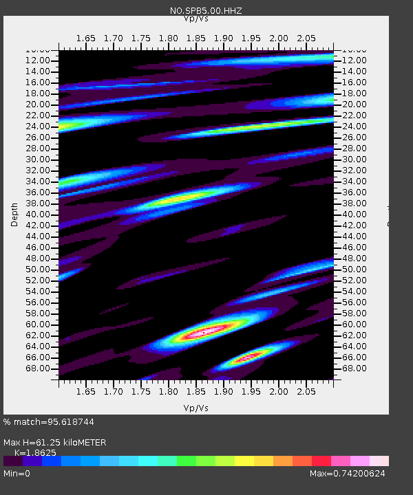
SPB5 - Earthquake Result Viewer
| Earthquake location: |
Near East Coast Of Kamchatka |
| Earthquake latitude/longitude: |
51.6/157.9 |
| Earthquake time(UTC): |
2018/07/06 (187) 01:40:08 GMT |
| Earthquake Depth: |
80 km |
| Earthquake Magnitude: |
6.1 Mwp |
| Earthquake Catalog/Contributor: |
NEIC PDE/us |
|
| Network: |
NO Norwegian Seismic Array Network |
| Station: |
SPB5 |
| Lat/Lon: |
78.18 N/16.37 E |
| Elevation: |
295 m |
|
| Distance: |
48.4 deg |
| Az: |
350.111 deg |
| Baz: |
31.302 deg |
| Ray Param: |
0.06915766 |
| Estimated Moho Depth: |
61.25 km |
| Estimated Crust Vp/Vs: |
1.86 |
| Assumed Crust Vp: |
6.545 km/s |
| Estimated Crust Vs: |
3.514 km/s |
| Estimated Crust Poisson's Ratio: |
0.30 |
|
| Radial Match: |
95.618744 % |
| Radial Bump: |
379 |
| Transverse Match: |
89.50317 % |
| Transverse Bump: |
400 |
| SOD ConfigId: |
2752131 |
| Insert Time: |
2018-07-20 01:52:57.548 +0000 |
| GWidth: |
2.5 |
| Max Bumps: |
400 |
| Tol: |
0.001 |
|

Signal To Noise
| Channel | StoN | STA | LTA |
| NO:SPB5:00:HHZ:20180706T01:48:11.624998Z | 69.23627 | 2.181167E-6 | 3.1503244E-8 |
| NO:SPB5:00:HHN:20180706T01:48:11.624998Z | 19.734232 | 8.1177996E-7 | 4.1135625E-8 |
| NO:SPB5:00:HHE:20180706T01:48:11.624998Z | 25.382618 | 7.0584696E-7 | 2.780828E-8 |
| Arrivals |
| Ps | 8.6 SECOND |
| PpPs | 25 SECOND |
| PsPs/PpSs | 34 SECOND |


