You are here: Home > Network List > NM - Cooperative New Madrid Seismic Network Stations List
> Station LPAR Lepanto,AR > Earthquake Result Viewer
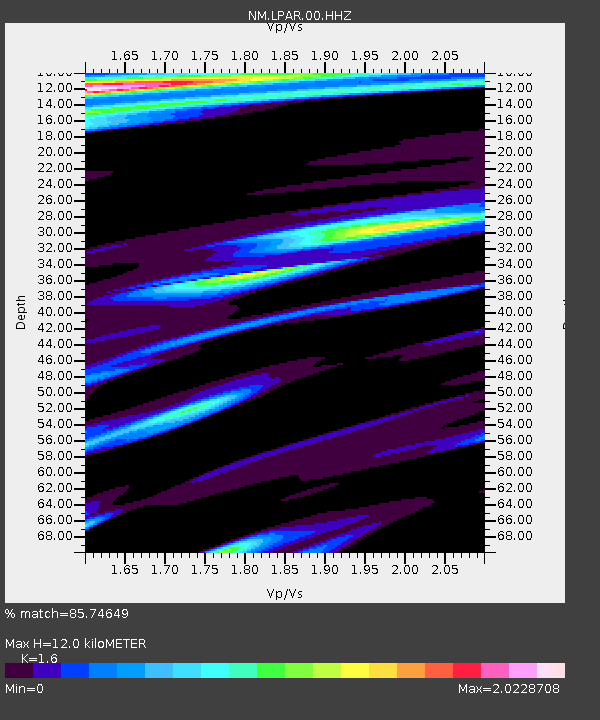
LPAR Lepanto,AR - Earthquake Result Viewer
| Earthquake location: |
Northern Mid-Atlantic Ridge |
| Earthquake latitude/longitude: |
10.7/-43.4 |
| Earthquake time(UTC): |
2022/03/22 (081) 16:35:08 GMT |
| Earthquake Depth: |
10 km |
| Earthquake Magnitude: |
6.7 mww |
| Earthquake Catalog/Contributor: |
NEIC PDE/us |
|
| Network: |
NM Cooperative New Madrid Seismic Network |
| Station: |
LPAR Lepanto,AR |
| Lat/Lon: |
35.60 N/90.30 W |
| Elevation: |
67 m |
|
| Distance: |
49.1 deg |
| Az: |
308.084 deg |
| Baz: |
108.351 deg |
| Ray Param: |
0.06890193 |
| Estimated Moho Depth: |
12.0 km |
| Estimated Crust Vp/Vs: |
1.60 |
| Assumed Crust Vp: |
6.273 km/s |
| Estimated Crust Vs: |
3.921 km/s |
| Estimated Crust Poisson's Ratio: |
0.18 |
|
| Radial Match: |
85.74649 % |
| Radial Bump: |
355 |
| Transverse Match: |
67.59619 % |
| Transverse Bump: |
400 |
| SOD ConfigId: |
27527651 |
| Insert Time: |
2022-04-05 16:57:58.951 +0000 |
| GWidth: |
2.5 |
| Max Bumps: |
400 |
| Tol: |
0.001 |
|

Signal To Noise
| Channel | StoN | STA | LTA |
| NM:LPAR:00:HHZ:20220322T16:43:24.770007Z | 6.631918 | 1.5905603E-6 | 2.3983412E-7 |
| NM:LPAR:00:HHN:20220322T16:43:24.770007Z | 0.5916476 | 3.7941135E-7 | 6.4127926E-7 |
| NM:LPAR:00:HHE:20220322T16:43:24.770007Z | 1.2992183 | 9.303241E-7 | 7.160645E-7 |
| Arrivals |
| Ps | 1.2 SECOND |
| PpPs | 4.7 SECOND |
| PsPs/PpSs | 5.9 SECOND |


