You are here: Home > Network List > O2 - Oklahoma Consolidated Temporary Seismic Networks Stations List
> Station PW01 Pawnee, Oklahoma > Earthquake Result Viewer
PW01 Pawnee, Oklahoma - Earthquake Result Viewer
| Earthquake location: |
Northern Mid-Atlantic Ridge |
| Earthquake latitude/longitude: |
10.7/-43.4 |
| Earthquake time(UTC): |
2022/03/22 (081) 16:35:08 GMT |
| Earthquake Depth: |
10 km |
| Earthquake Magnitude: |
6.7 mww |
| Earthquake Catalog/Contributor: |
NEIC PDE/us |
|
| Network: |
O2 Oklahoma Consolidated Temporary Seismic Networks |
| Station: |
PW01 Pawnee, Oklahoma |
| Lat/Lon: |
36.40 N/96.93 W |
| Elevation: |
322 m |
|
| Distance: |
54.5 deg |
| Az: |
307.16 deg |
| Baz: |
103.896 deg |
| Ray Param: |
0.06540838 |
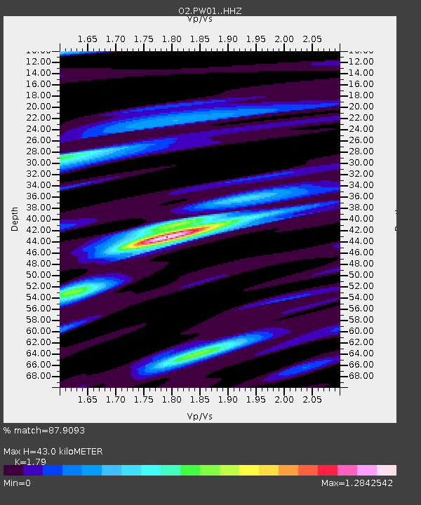
| Estimated Moho Depth: |
43.0 km |
| Estimated Crust Vp/Vs: |
1.79 |
| Assumed Crust Vp: |
6.483 km/s |
| Estimated Crust Vs: |
3.622 km/s |
| Estimated Crust Poisson's Ratio: |
0.27 |
|
| Radial Match: |
87.9093 % |
| Radial Bump: |
400 |
| Transverse Match: |
64.29249 % |
| Transverse Bump: |
400 |
| SOD ConfigId: |
27527651 |
| Insert Time: |
2022-04-05 17:00:18.173 +0000 |
| GWidth: |
2.5 |
| Max Bumps: |
400 |
| Tol: |
0.001 |
|

Signal To Noise
| Channel | StoN | STA | LTA |
| O2:PW01: :HHZ:20220322T16:44:04.875018Z | 8.270294 | 1.3641651E-6 | 1.6494758E-7 |
| O2:PW01: :HHN:20220322T16:44:04.875018Z | 2.0927143 | 4.938852E-7 | 2.360022E-7 |
| O2:PW01: :HHE:20220322T16:44:04.875018Z | 4.209347 | 6.0158806E-7 | 1.429172E-7 |
| Arrivals |
| Ps | 5.5 SECOND |
| PpPs | 18 SECOND |
| PsPs/PpSs | 23 SECOND |


