You are here: Home > Network List > O2 - Oklahoma Consolidated Temporary Seismic Networks Stations List
> Station PW30 Pawnee, Oklahoma, USA > Earthquake Result Viewer
PW30 Pawnee, Oklahoma, USA - Earthquake Result Viewer
| Earthquake location: |
Northern Mid-Atlantic Ridge |
| Earthquake latitude/longitude: |
10.7/-43.4 |
| Earthquake time(UTC): |
2022/03/22 (081) 16:35:08 GMT |
| Earthquake Depth: |
10 km |
| Earthquake Magnitude: |
6.7 mww |
| Earthquake Catalog/Contributor: |
NEIC PDE/us |
|
| Network: |
O2 Oklahoma Consolidated Temporary Seismic Networks |
| Station: |
PW30 Pawnee, Oklahoma, USA |
| Lat/Lon: |
36.42 N/96.82 W |
| Elevation: |
314 m |
|
| Distance: |
54.4 deg |
| Az: |
307.204 deg |
| Baz: |
103.985 deg |
| Ray Param: |
0.06546113 |
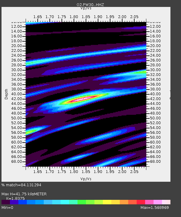
| Estimated Moho Depth: |
41.75 km |
| Estimated Crust Vp/Vs: |
1.84 |
| Assumed Crust Vp: |
6.483 km/s |
| Estimated Crust Vs: |
3.528 km/s |
| Estimated Crust Poisson's Ratio: |
0.29 |
|
| Radial Match: |
84.131294 % |
| Radial Bump: |
374 |
| Transverse Match: |
39.099976 % |
| Transverse Bump: |
400 |
| SOD ConfigId: |
27527651 |
| Insert Time: |
2022-04-05 17:00:31.082 +0000 |
| GWidth: |
2.5 |
| Max Bumps: |
400 |
| Tol: |
0.001 |
|

Signal To Noise
| Channel | StoN | STA | LTA |
| O2:PW30: :HHZ:20220322T16:44:04.289996Z | 5.4904356 | 1.1143184E-6 | 2.0295626E-7 |
| O2:PW30: :HHN:20220322T16:44:04.289996Z | 2.764734 | 1.5601967E-6 | 5.643207E-7 |
| O2:PW30: :HHE:20220322T16:44:04.289996Z | 2.9149432 | 9.184565E-7 | 3.1508557E-7 |
| Arrivals |
| Ps | 5.7 SECOND |
| PpPs | 17 SECOND |
| PsPs/PpSs | 23 SECOND |


