You are here: Home > Network List > TX - Texas Seismological Network Stations List
> Station 435B Jarrell, TX, USA > Earthquake Result Viewer
435B Jarrell, TX, USA - Earthquake Result Viewer
| Earthquake location: |
Northern Mid-Atlantic Ridge |
| Earthquake latitude/longitude: |
10.7/-43.4 |
| Earthquake time(UTC): |
2022/03/22 (081) 16:35:08 GMT |
| Earthquake Depth: |
10 km |
| Earthquake Magnitude: |
6.7 mww |
| Earthquake Catalog/Contributor: |
NEIC PDE/us |
|
| Network: |
TX Texas Seismological Network |
| Station: |
435B Jarrell, TX, USA |
| Lat/Lon: |
30.78 N/97.58 W |
| Elevation: |
248 m |
|
| Distance: |
53.9 deg |
| Az: |
300.257 deg |
| Baz: |
99.494 deg |
| Ray Param: |
0.06578515 |
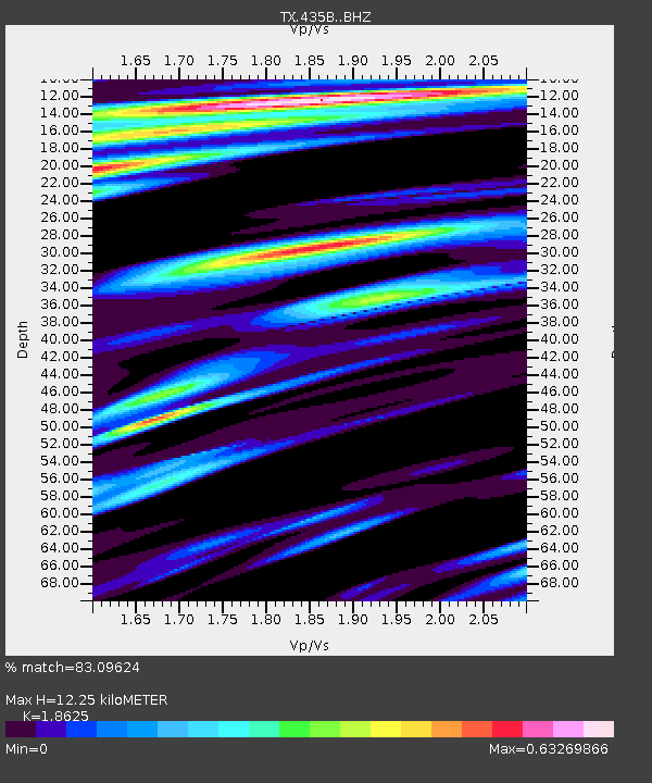
| Estimated Moho Depth: |
12.25 km |
| Estimated Crust Vp/Vs: |
1.86 |
| Assumed Crust Vp: |
6.347 km/s |
| Estimated Crust Vs: |
3.408 km/s |
| Estimated Crust Poisson's Ratio: |
0.30 |
|
| Radial Match: |
83.09624 % |
| Radial Bump: |
400 |
| Transverse Match: |
66.266464 % |
| Transverse Bump: |
400 |
| SOD ConfigId: |
27527651 |
| Insert Time: |
2022-04-05 17:05:27.128 +0000 |
| GWidth: |
2.5 |
| Max Bumps: |
400 |
| Tol: |
0.001 |
|

Signal To Noise
| Channel | StoN | STA | LTA |
| TX:435B: :BHZ:20220322T16:44:00.524005Z | 5.0377493 | 1.1672925E-6 | 2.3170911E-7 |
| TX:435B: :BHN:20220322T16:44:00.524005Z | 1.0912325 | 1.812604E-7 | 1.6610612E-7 |
| TX:435B: :BHE:20220322T16:44:00.524005Z | 2.6613052 | 4.4441845E-7 | 1.6699268E-7 |
| Arrivals |
| Ps | 1.7 SECOND |
| PpPs | 5.3 SECOND |
| PsPs/PpSs | 7.0 SECOND |


