You are here: Home > Network List > TX - Texas Seismological Network Stations List
> Station HNDO Hondo > Earthquake Result Viewer
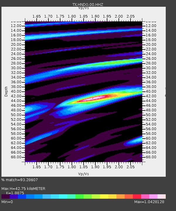
HNDO Hondo - Earthquake Result Viewer
| Earthquake location: |
Northern Mid-Atlantic Ridge |
| Earthquake latitude/longitude: |
10.7/-43.4 |
| Earthquake time(UTC): |
2022/03/22 (081) 16:35:08 GMT |
| Earthquake Depth: |
10 km |
| Earthquake Magnitude: |
6.7 mww |
| Earthquake Catalog/Contributor: |
NEIC PDE/us |
|
| Network: |
TX Texas Seismological Network |
| Station: |
HNDO Hondo |
| Lat/Lon: |
29.53 N/99.28 W |
| Elevation: |
381 m |
|
| Distance: |
55.2 deg |
| Az: |
298.471 deg |
| Baz: |
97.611 deg |
| Ray Param: |
0.06496635 |
| Estimated Moho Depth: |
42.75 km |
| Estimated Crust Vp/Vs: |
1.89 |
| Assumed Crust Vp: |
6.347 km/s |
| Estimated Crust Vs: |
3.363 km/s |
| Estimated Crust Poisson's Ratio: |
0.30 |
|
| Radial Match: |
93.28607 % |
| Radial Bump: |
278 |
| Transverse Match: |
79.18962 % |
| Transverse Bump: |
400 |
| SOD ConfigId: |
27527651 |
| Insert Time: |
2022-04-05 17:05:57.054 +0000 |
| GWidth: |
2.5 |
| Max Bumps: |
400 |
| Tol: |
0.001 |
|

Signal To Noise
| Channel | StoN | STA | LTA |
| TX:HNDO:00:HHZ:20220322T16:44:09.690021Z | 5.4975986 | 1.1978879E-6 | 2.1789293E-7 |
| TX:HNDO:00:HH1:20220322T16:44:09.690021Z | 3.4963233 | 3.5943532E-7 | 1.02803796E-7 |
| TX:HNDO:00:HH2:20220322T16:44:09.690021Z | 2.9275272 | 3.8359323E-7 | 1.3102978E-7 |
| Arrivals |
| Ps | 6.3 SECOND |
| PpPs | 19 SECOND |
| PsPs/PpSs | 25 SECOND |


