You are here: Home > Network List > US - United States National Seismic Network Stations List
> Station DGMT Dagmar, Montana, USA > Earthquake Result Viewer
DGMT Dagmar, Montana, USA - Earthquake Result Viewer

| Earthquake location: |
Northern Mid-Atlantic Ridge |
| Earthquake latitude/longitude: |
10.7/-43.4 |
| Earthquake time(UTC): |
2022/03/22 (081) 16:35:08 GMT |
| Earthquake Depth: |
10 km |
| Earthquake Magnitude: |
6.7 mww |
| Earthquake Catalog/Contributor: |
NEIC PDE/us |
|
| Network: |
US United States National Seismic Network |
| Station: |
DGMT Dagmar, Montana, USA |
| Lat/Lon: |
48.47 N/104.20 W |
| Elevation: |
0.0 m |
|
| Distance: |
62.8 deg |
| Az: |
319.211 deg |
| Baz: |
105.282 deg |
| Ray Param: |
0.05999053 |
| Estimated Moho Depth: |
63.0 km |
| Estimated Crust Vp/Vs: |
1.75 |
| Assumed Crust Vp: |
6.438 km/s |
| Estimated Crust Vs: |
3.673 km/s |
| Estimated Crust Poisson's Ratio: |
0.26 |
|
| Radial Match: |
81.77195 % |
| Radial Bump: |
400 |
| Transverse Match: |
92.06249 % |
| Transverse Bump: |
184 |
| SOD ConfigId: |
27527651 |
| Insert Time: |
2022-04-05 17:08:21.603 +0000 |
| GWidth: |
2.5 |
| Max Bumps: |
400 |
| Tol: |
0.001 |
|
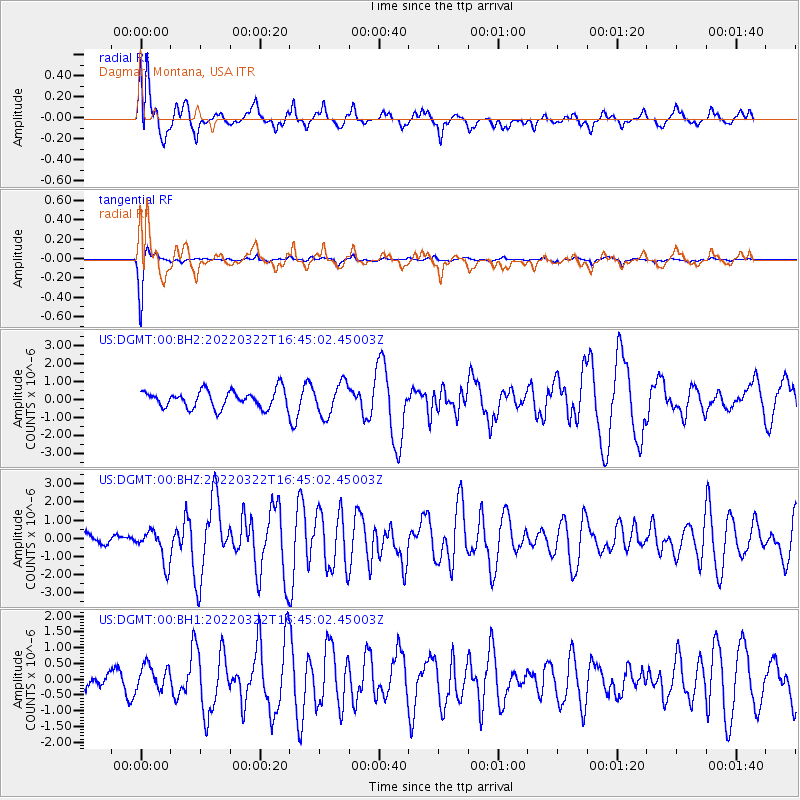
Signal To Noise
| Channel | StoN | STA | LTA |
| US:DGMT:00:BHZ:20220322T16:45:02.45003Z | 3.519596 | 9.1140737E-7 | 2.5895227E-7 |
| US:DGMT:00:BH1:20220322T16:45:02.45003Z | 0.8036145 | 4.0845188E-7 | 5.0826844E-7 |
| US:DGMT:00:BH2:20220322T16:45:02.45003Z | 1.8311806 | 8.8777955E-7 | 4.848127E-7 |
| Arrivals |
| Ps | 7.7 SECOND |
| PpPs | 26 SECOND |
| PsPs/PpSs | 33 SECOND |


