You are here: Home > Network List > US - United States National Seismic Network Stations List
> Station HAWA Hanford, Washington, USA > Earthquake Result Viewer
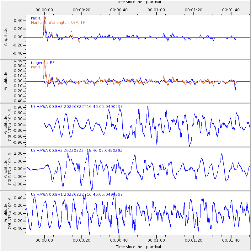
HAWA Hanford, Washington, USA - Earthquake Result Viewer
*The percent match for this event was below the threshold and hence no stack was calculated.
| Earthquake location: |
Northern Mid-Atlantic Ridge |
| Earthquake latitude/longitude: |
10.7/-43.4 |
| Earthquake time(UTC): |
2022/03/22 (081) 16:35:08 GMT |
| Earthquake Depth: |
10 km |
| Earthquake Magnitude: |
6.7 mww |
| Earthquake Catalog/Contributor: |
NEIC PDE/us |
|
| Network: |
US United States National Seismic Network |
| Station: |
HAWA Hanford, Washington, USA |
| Lat/Lon: |
46.39 N/119.53 W |
| Elevation: |
364 m |
|
| Distance: |
72.8 deg |
| Az: |
315.279 deg |
| Baz: |
92.495 deg |
| Ray Param: |
$rayparam |
*The percent match for this event was below the threshold and hence was not used in the summary stack. |
|
| Radial Match: |
78.95165 % |
| Radial Bump: |
400 |
| Transverse Match: |
57.806973 % |
| Transverse Bump: |
400 |
| SOD ConfigId: |
27527651 |
| Insert Time: |
2022-04-05 17:08:39.036 +0000 |
| GWidth: |
2.5 |
| Max Bumps: |
400 |
| Tol: |
0.001 |
|
Signal To Noise
| Channel | StoN | STA | LTA |
| US:HAWA:00:BHZ:20220322T16:46:05.049029Z | 3.7109206 | 7.179086E-7 | 1.9345836E-7 |
| US:HAWA:00:BH1:20220322T16:46:05.049029Z | 1.4478701 | 2.4825857E-7 | 1.7146468E-7 |
| US:HAWA:00:BH2:20220322T16:46:05.049029Z | 1.3344805 | 3.7218504E-7 | 2.7889882E-7 |
| Arrivals |
| Ps | |
| PpPs | |
| PsPs/PpSs | |


