You are here: Home > Network List > TX - Texas Seismological Network Stations List
> Station SN03 Snyder 3 > Earthquake Result Viewer
SN03 Snyder 3 - Earthquake Result Viewer
| Earthquake location: |
Near East Coast Of Kamchatka |
| Earthquake latitude/longitude: |
51.6/157.9 |
| Earthquake time(UTC): |
2018/07/06 (187) 01:40:08 GMT |
| Earthquake Depth: |
80 km |
| Earthquake Magnitude: |
6.1 Mwp |
| Earthquake Catalog/Contributor: |
NEIC PDE/us |
|
| Network: |
TX Texas Seismological Network |
| Station: |
SN03 Snyder 3 |
| Lat/Lon: |
32.92 N/100.94 W |
| Elevation: |
744 m |
|
| Distance: |
71.3 deg |
| Az: |
60.589 deg |
| Baz: |
319.772 deg |
| Ray Param: |
0.054249305 |
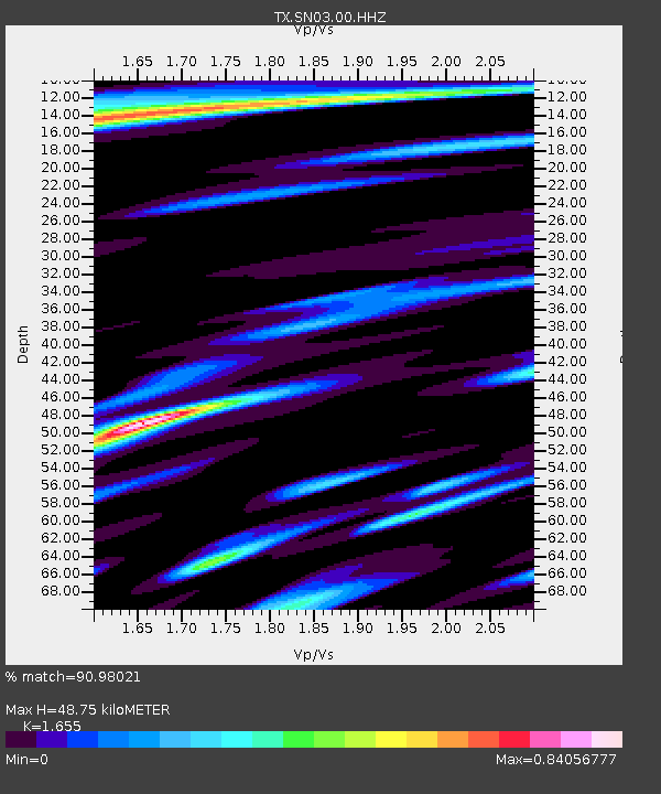
| Estimated Moho Depth: |
48.75 km |
| Estimated Crust Vp/Vs: |
1.65 |
| Assumed Crust Vp: |
6.426 km/s |
| Estimated Crust Vs: |
3.883 km/s |
| Estimated Crust Poisson's Ratio: |
0.21 |
|
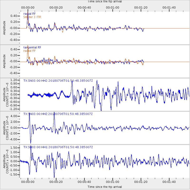
| Radial Match: |
90.98021 % |
| Radial Bump: |
400 |
| Transverse Match: |
69.338455 % |
| Transverse Bump: |
400 |
| SOD ConfigId: |
2752131 |
| Insert Time: |
2018-07-20 01:54:18.984 +0000 |
| GWidth: |
2.5 |
| Max Bumps: |
400 |
| Tol: |
0.001 |
|
Signal To Noise
| Channel | StoN | STA | LTA |
| TX:SN03:00:HHZ:20180706T01:50:48.385007Z | 23.570435 | 2.282731E-6 | 9.684721E-8 |
| TX:SN03:00:HH1:20180706T01:50:48.385007Z | 6.5465665 | 7.198454E-7 | 1.099577E-7 |
| TX:SN03:00:HH2:20180706T01:50:48.385007Z | 3.8925638 | 4.958202E-7 | 1.2737625E-7 |
| Arrivals |
| Ps | 5.2 SECOND |
| PpPs | 19 SECOND |
| PsPs/PpSs | 25 SECOND |


