You are here: Home > Network List > XM99 - Rio Grande Seismic Transect Stations List
> Station AZ47 Arizona47 > Earthquake Result Viewer
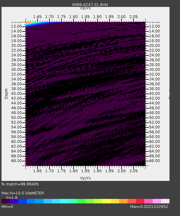
AZ47 Arizona47 - Earthquake Result Viewer
| Earthquake location: |
Bonin Islands, Japan Region |
| Earthquake latitude/longitude: |
26.3/140.5 |
| Earthquake time(UTC): |
2000/10/27 (301) 04:21:51 GMT |
| Earthquake Depth: |
388 km |
| Earthquake Magnitude: |
6.1 MB, 6.1 MW, 6.0 MW |
| Earthquake Catalog/Contributor: |
WHDF/NEIC |
|
| Network: |
XM Rio Grande Seismic Transect |
| Station: |
AZ47 Arizona47 |
| Lat/Lon: |
36.64 N/109.33 W |
| Elevation: |
1752 m |
|
| Distance: |
89.3 deg |
| Az: |
49.017 deg |
| Baz: |
302.572 deg |
| Ray Param: |
0.041658662 |
| Estimated Moho Depth: |
10.0 km |
| Estimated Crust Vp/Vs: |
1.60 |
| Assumed Crust Vp: |
6.476 km/s |
| Estimated Crust Vs: |
4.047 km/s |
| Estimated Crust Poisson's Ratio: |
0.18 |
|
| Radial Match: |
99.99485 % |
| Radial Bump: |
2 |
| Transverse Match: |
99.987785 % |
| Transverse Bump: |
2 |
| SOD ConfigId: |
16820 |
| Insert Time: |
2010-02-26 17:19:11.845 +0000 |
| GWidth: |
2.5 |
| Max Bumps: |
400 |
| Tol: |
0.001 |
|

Signal To Noise
| Channel | StoN | STA | LTA |
| XM:AZ47:01:BHN:20001027T04:33:33.631006Z | 0.9115039 | 9.742758E-7 | 1.0688664E-6 |
| XM:AZ47:01:BHE:20001027T04:33:33.631006Z | 0.9446145 | 7.0369646E-7 | 7.4495625E-7 |
| XM:AZ47:01:BHZ:20001027T04:33:33.631006Z | 0.9119417 | 8.9620556E-7 | 9.827444E-7 |
| Arrivals |
| Ps | 0.9 SECOND |
| PpPs | 3.9 SECOND |
| PsPs/PpSs | 4.9 SECOND |


