You are here: Home > Network List > TX - Texas Seismological Network Stations List
> Station PB01 Permian Basin 1 > Earthquake Result Viewer
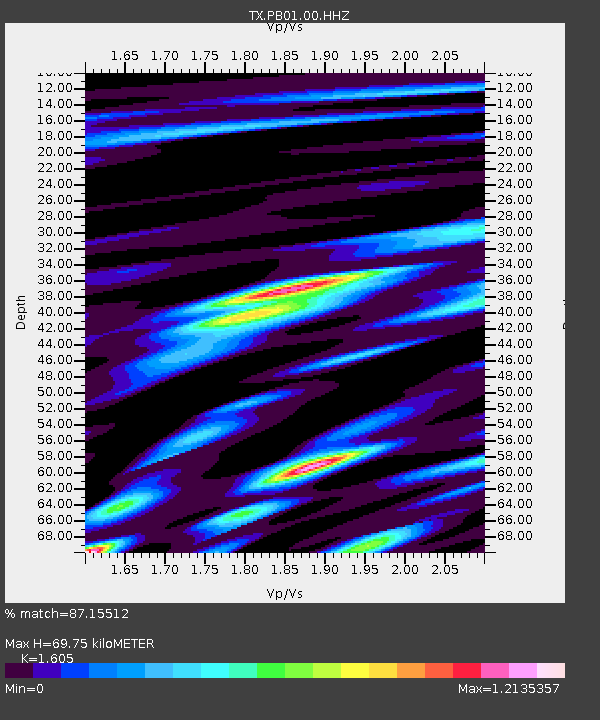
PB01 Permian Basin 1 - Earthquake Result Viewer
| Earthquake location: |
Near East Coast Of Kamchatka |
| Earthquake latitude/longitude: |
51.6/157.9 |
| Earthquake time(UTC): |
2018/07/06 (187) 01:40:08 GMT |
| Earthquake Depth: |
80 km |
| Earthquake Magnitude: |
6.1 Mwp |
| Earthquake Catalog/Contributor: |
NEIC PDE/us |
|
| Network: |
TX Texas Seismological Network |
| Station: |
PB01 Permian Basin 1 |
| Lat/Lon: |
30.94 N/103.78 W |
| Elevation: |
1010 m |
|
| Distance: |
71.2 deg |
| Az: |
63.883 deg |
| Baz: |
319.336 deg |
| Ray Param: |
0.054291945 |
| Estimated Moho Depth: |
69.75 km |
| Estimated Crust Vp/Vs: |
1.61 |
| Assumed Crust Vp: |
6.121 km/s |
| Estimated Crust Vs: |
3.813 km/s |
| Estimated Crust Poisson's Ratio: |
0.18 |
|
| Radial Match: |
87.15512 % |
| Radial Bump: |
400 |
| Transverse Match: |
76.79312 % |
| Transverse Bump: |
400 |
| SOD ConfigId: |
2752131 |
| Insert Time: |
2018-07-20 01:54:40.071 +0000 |
| GWidth: |
2.5 |
| Max Bumps: |
400 |
| Tol: |
0.001 |
|

Signal To Noise
| Channel | StoN | STA | LTA |
| TX:PB01:00:HHZ:20180706T01:50:47.999998Z | 21.070147 | 1.9184288E-6 | 9.104962E-8 |
| TX:PB01:00:HH1:20180706T01:50:47.999998Z | 3.698319 | 5.218142E-7 | 1.4109496E-7 |
| TX:PB01:00:HH2:20180706T01:50:47.999998Z | 5.8467226 | 7.8839713E-7 | 1.3484429E-7 |
| Arrivals |
| Ps | 7.1 SECOND |
| PpPs | 29 SECOND |
| PsPs/PpSs | 36 SECOND |


